


{"cover":"Professional landscape format (1536×1024) hero image with bold text overlay: 'GNSS Enhancements in Party Wall Act Boundary Disputes: Centimeter Accuracy for 2026 Resolutions' in extra large 70pt white bold sans-serif font with dark semi-transparent background box for contrast, centered upper-third composition. Background shows a dramatic aerial view of densely packed London terraced housing rows with visible party walls and boundary lines, overlaid with subtle blue GNSS satellite signal grid lines and GPS coordinate markers. Color palette: deep navy blue, crisp white, gold accent lines. Editorial magazine quality, high contrast, professional surveying theme.","content":["Landscape format (1536×1024) editorial illustration showing a professional land surveyor in high-visibility vest using a modern RTK GNSS receiver on a tripod beside a brick party wall in a London residential street, with a digital display showing centimeter-level coordinate readouts and satellite constellation icons overhead. Blue and white color scheme, technical precision aesthetic, urban construction backdrop with scaffolding, realistic documentary photography style, sharp focus on the GNSS equipment and boundary marker.","Landscape format (1536×1024) technical infographic-style image showing a side-by-side comparison diagram: left panel displays traditional boundary survey with meter-level error margins shown as wide red shaded zones around a property line; right panel shows RTK-GNSS enhanced survey with tight 1-2cm green precision bands. Center divider labeled '2026 GNSS Technology'. Includes small icons for GPS, GLONASS, Galileo, BeiDou satellite constellations at top. Clean white background, professional data visualization aesthetic, navy and green color palette, engineering diagram style.","Landscape format (1536×1024) close-up scene of two property owners and a party wall surveyor gathered around a tablet displaying an augmented reality boundary line overlay on a live camera view of a garden fence and wall, with GNSS RTK receiver clipped to the tablet. Background shows a London semi-detached property with a disputed boundary wall. Warm professional lighting, photorealistic style, showing the practical resolution moment, with visible coordinate accuracy readout of 1.2cm on the tablet screen, conveying dispute resolution and modern technology convergence."]
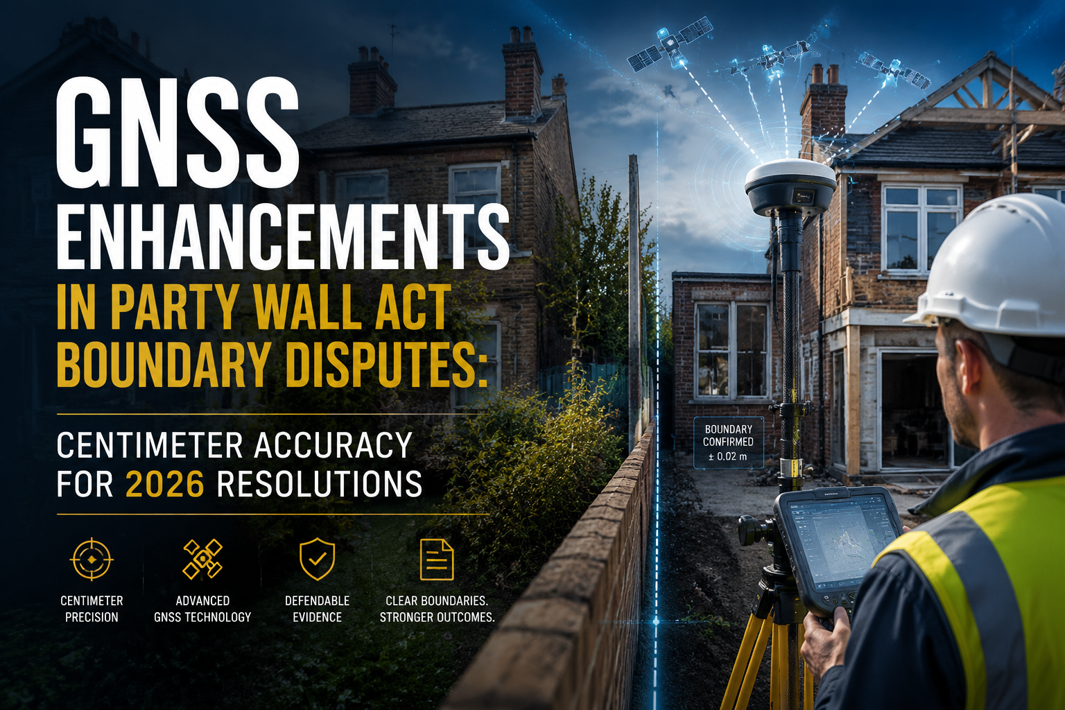
Boundary disputes under the Party Wall etc. Act 1996 cost UK property owners an estimated tens of millions of pounds each year in legal fees, surveyor costs, and delayed construction projects — and the root cause is often a measurement disagreement of just a few centimetres. That gap between what one owner believes and what another insists upon has historically been bridged by traditional optical survey instruments carrying errors of 5 cm or more. In 2026, that gap is closing fast. GNSS enhancements in Party Wall Act boundary disputes are delivering centimeter accuracy for 2026 resolutions, transforming how surveyors establish, defend, and record boundary positions in high-stakes urban construction projects.

Key Takeaways
- Modern RTK GNSS systems now routinely achieve 1-2 cm absolute accuracy, meeting or exceeding requirements for virtually all property boundary survey applications [8].
- Multi-constellation receivers drawing on GPS, GLONASS, Galileo, and BeiDou signals dramatically improve reliability in dense urban environments [6].
- New software-defined receiver technology, such as FocalPoint Positioning's Precise+, delivers sub-metre accuracy without sensor fusion, even in challenging signal conditions [1].
- RTK-SLAM hybrid systems maintain decimeter-level accuracy indoors and centimeter-level accuracy in open-sky conditions, extending GNSS utility to enclosed boundary surveys [2].
- Compact, affordable GNSS hardware from manufacturers like Emlid and ArduSimple is making high-precision boundary surveys accessible to a wider range of practitioners [3].
Why Boundary Accuracy Matters Under the Party Wall Act
The Party Wall etc. Act 1996 governs construction work that affects shared walls, boundary walls, and excavations near neighbouring properties. When a building owner serves a party wall notice on an adjoining owner, the legal process that follows depends heavily on one foundational question: exactly where does the boundary lie?
Even a 3 cm error in boundary placement can determine whether a new foundation encroaches on a neighbour's land, whether a wall extension sits wholly within one owner's title, or whether a party fence wall is truly shared. When surveyors disagree on that position, disputes escalate. A party wall award can be challenged in court, construction programmes stall, and costs spiral.
Traditional survey methods — total stations, optical theodolites, and tape measures — carry inherent limitations in dense urban settings. Signal obstruction, atmospheric refraction, and human error all contribute to positional uncertainty. GNSS technology, particularly Real-Time Kinematic (RTK) positioning, addresses these limitations directly.
The Legal Stakes of a Millimetre
Under the Act, a building owner has defined rights to build on or at the line of junction. The precision of that line is not merely technical; it is legally consequential. Courts and appointed surveyors have increasingly recognised that positional evidence supported by high-accuracy GNSS data carries greater weight than measurements derived from older methods. In 2026, surveyors who arrive at a dispute armed with centimeter-accurate GNSS data are better positioned — in every sense — to resolve matters efficiently.
How GNSS Technology Has Advanced for 2026 Boundary Surveys
The surveying profession has witnessed a rapid acceleration in GNSS capability over the past three years. Several converging developments now make GNSS enhancements in Party Wall Act boundary disputes a practical reality rather than an aspirational goal.
RTK Positioning: The Accuracy Foundation
Real-Time Kinematic GNSS remains the cornerstone of high-precision boundary work. RTK systems use a base station with a known position to calculate and transmit correction data to a rover receiver in real time. The result is positional accuracy of 1-2 cm horizontally — sufficient for virtually all property boundary applications [8].
Differential correction techniques remove systematic errors caused by satellite clock drift, atmospheric delay, and orbital inaccuracies [7]. When applied in the field during a party wall survey, these corrections transform a standard GNSS reading into a legally defensible measurement.
A 1-2 cm RTK accuracy figure is not merely impressive engineering — it is the difference between a boundary that holds up in an award and one that invites challenge.
Multi-Constellation Receivers: More Signals, Greater Reliability
One of the most significant advances in 2026 is the widespread adoption of multi-constellation GNSS receivers. These devices simultaneously process signals from four major satellite systems: the US GPS constellation, Russia's GLONASS, the European Galileo network, and China's BeiDou system [6].
In dense London streetscapes — where tall buildings, trees, and scaffolding routinely obstruct satellite views — a receiver limited to one constellation may track as few as four satellites, the minimum for a position fix. A multi-constellation receiver in the same location might track 20 or more satellites, dramatically improving geometric strength and accuracy.
Key benefits of multi-constellation receivers for boundary surveys:
- Reduced signal dropout in urban canyons
- Faster initialisation time for RTK solutions
- Improved accuracy in partially obstructed environments
- Greater redundancy if individual satellites are unavailable
FocalPoint Precise+: Sub-Metre Accuracy Without Sensor Fusion
In May 2026, FocalPoint Positioning launched Precise+, a software-defined receiver technology that achieves sub-metre GNSS accuracy without relying on inertial sensors or sensor fusion. In validation testing at Thetford Forest — a challenging, signal-degraded environment — Precise+ achieved 80 cm accuracy at the 99th percentile. Competing state-of-the-art receivers recorded errors exceeding three metres under the same conditions [1].
For party wall surveyors working in environments where tree canopy or building overhangs compromise signal quality, this represents a meaningful step forward. Even where full RTK accuracy cannot be achieved, sub-metre positioning still supports boundary identification with a precision far exceeding traditional methods.
RTK-SLAM: Taking Precision Indoors
A significant limitation of conventional GNSS is its dependence on open-sky signal reception. Party wall surveys frequently require work inside buildings, in basements, or in enclosed courtyards where satellite signals are unavailable.
Recent research has demonstrated that RTK-SLAM systems — which combine RTK GNSS positioning with Simultaneous Localisation and Mapping — can achieve centimeter-level absolute accuracy in open-sky conditions and maintain decimeter-level accuracy indoors [2]. The SLAM component uses sensor data to continue mapping and positioning when GNSS signals are lost, then re-anchors to GNSS coordinates when the receiver returns to open sky.
This hybrid approach is particularly valuable for surveys involving types of party wall works that include basement excavations or internal structural alterations where the boundary line must be traced through the building envelope.
Compact Hardware: Professional Accuracy at Accessible Cost
The barrier to high-precision GNSS has historically been cost. Manufacturers including Emlid, ArduSimple, and u-blox have introduced compact RTK receivers that deliver professional-grade accuracy at a fraction of the cost of traditional survey-grade equipment [3]. These devices are small enough to carry in a jacket pocket, yet capable of centimeter-level RTK positioning when paired with a correction data service.
A joint validation by Oscilloquartz and Tupaia in early 2026 demonstrated that high-accuracy GNSS positioning can be achieved using existing mobile network timing infrastructure, reducing the need for dedicated base stations and lowering deployment complexity [5]. For surveyors operating across multiple London boroughs in a single day, this is a practical and cost-relevant development.
The real challenge, as infrastructure analysts have noted, is not technical feasibility but the cost of delivering centimeter precision reliably across large geographic areas. Infrastructure density — the spacing of correction network reference stations — remains the primary determinant of cost-effectiveness [9].
Practical Application: GNSS in Party Wall Dispute Resolution

Understanding how these technologies translate into resolved disputes requires a look at the workflow a surveyor follows on a live Party Wall Act case.
Step 1: Pre-Survey Data Integration
Before attending site, a surveyor integrates title register data, historic OS mapping, and any existing survey plans. GNSS coordinates from the Land Registry's digital mapping can be imported directly into the receiver's field software, establishing a reference framework before a single measurement is taken.
Step 2: On-Site RTK Survey
At the property, the surveyor establishes an RTK fix using a correction data service — either a Network RTK subscription (such as Ordnance Survey's OS Net) or a local base station. Once initialised, the rover is used to measure:
- The physical position of existing walls, fences, and structures
- The position of boundary features referenced in title deeds
- Any encroachments or deviations from the recorded boundary line
Each measurement is time-stamped and logged with its associated accuracy estimate, creating an auditable record.
Step 3: Augmented Reality Boundary Visualisation
Smartphone-based RTK solutions now allow surveyors to display boundary lines in augmented reality on a device screen, overlaying the legal boundary position onto a live camera view of the physical site [4]. This capability is transformative for on-site dispute resolution. When both parties can see the boundary line projected onto the actual wall or fence in real time, disagreements that might otherwise require weeks of correspondence can be resolved in a single site visit.
Step 4: Evidential Documentation for the Award
The GNSS survey data is processed and incorporated into the party wall award as a schedule of condition and boundary record. Coordinate data referenced to the National Grid, with stated accuracy metrics, provides a legally robust foundation that is far harder to challenge than a hand-drawn sketch or a tape measurement.
Surveyors preparing a schedule of condition now routinely include GNSS-referenced photographs and coordinate tables, establishing an unambiguous baseline record of boundary positions before construction begins.
Addressing the Challenges: Urban Environments and Signal Degradation
Despite the advances outlined above, GNSS surveys in London's dense urban environment still face real challenges. Research evaluating smartphone GNSS accuracy has confirmed that while device hardware introduces some variation, the operational environment is the primary driver of error — and indoor settings and dense urban areas consistently degrade localisation [10].
Common signal degradation sources in party wall survey contexts:
| Environment | Primary Challenge | Recommended Mitigation |
|---|---|---|
| Urban canyon (tall buildings) | Multipath reflection | Multi-constellation receiver, SLAM integration |
| Basement or indoor | Signal loss | RTK-SLAM hybrid approach |
| Dense tree canopy | Signal attenuation | FocalPoint Precise+ technology |
| Scaffolding and cranes | Dynamic obstructions | Increased observation time, redundant measurements |
Surveyors working in Central London face the most demanding signal environments. The combination of multi-constellation receivers, software-defined processing, and RTK-SLAM integration provides a layered response to these challenges that no single technology could address alone.
Cost, Accessibility, and the 2026 Surveying Landscape
One of the most significant shifts in 2026 is the democratisation of high-precision GNSS. The convergence of compact hardware, cloud-based correction services, and software-defined receivers means that centimeter-accurate boundary surveys are no longer the exclusive domain of large geospatial firms with expensive equipment fleets [3].
For property owners and surveyors considering how to keep party wall costs down, this is meaningful news. When a boundary dispute can be resolved in a single site visit with GNSS evidence rather than through multiple rounds of correspondence and counter-surveys, the overall cost of the party wall process decreases. Faster resolution also means construction programmes are less likely to be delayed, reducing the indirect costs borne by building owners.
Surveyors operating across North London, South London, and East London are increasingly incorporating RTK GNSS as a standard element of their survey toolkit rather than a premium add-on.
Legal and Professional Considerations for GNSS Evidence
The admissibility and weight of GNSS survey evidence in party wall proceedings depends on how it is collected, documented, and presented. Several professional considerations apply.
Accuracy statements must be explicit. A GNSS measurement reported without an associated accuracy estimate is of limited evidential value. Surveyors should record the number of satellites tracked, the PDOP (Position Dilution of Precision) value, the correction method used, and the resulting estimated accuracy for each measurement.
Datum and coordinate system consistency is essential. All measurements should be referenced to OSGB36 National Grid coordinates and Ordnance Datum Newlyn (ODN) for heights, ensuring compatibility with Land Registry data and OS mapping.
Calibration and equipment certification. GNSS receivers used in evidential surveys should be calibrated and their firmware kept current. Equipment manufacturers' stated accuracy specifications should be verified against independent test data.
Integration with the Party Wall etc. Act 1996 framework. GNSS data does not replace the legal framework; it supports it. Surveyors must still follow the statutory process for serving notices, appointing surveyors, and issuing awards. The technology enhances the quality of evidence within that framework, it does not circumvent it.
The Future Direction: What Comes After 2026

The trajectory of GNSS enhancement points toward further integration with Building Information Modelling (BIM), automated boundary detection using machine learning, and real-time dispute resolution platforms that combine GNSS data with title register information.
PPP-RTK (Precise Point Positioning with RTK corrections) services are expanding their coverage, promising centimeter accuracy from a single receiver without a local base station — a development that will further reduce the cost and complexity of high-precision boundary surveys.
As augmented reality boundary visualisation matures [4], the prospect of a surveyor and two disputing neighbours standing at a wall and seeing the legal boundary line displayed in real time — with centimeter precision — moves from novelty to standard practice.
GNSS enhancements in Party Wall Act boundary disputes are not a future aspiration. They are a present reality that is reshaping how disputes are prevented, documented, and resolved in 2026.
Conclusion
The convergence of RTK GNSS, multi-constellation receivers, software-defined positioning, and RTK-SLAM integration has fundamentally changed what is achievable in boundary surveys under the Party Wall Act. Centimeter accuracy for 2026 resolutions is no longer a marketing claim — it is a documented, validated capability that reduces disputes, strengthens awards, and protects both building owners and their neighbours.
Actionable next steps for property owners and surveyors:
- Specify GNSS accuracy requirements in any party wall surveyor appointment, requesting that boundary measurements be taken with RTK GNSS equipment and documented with accuracy metadata.
- Request coordinate-referenced boundary records as part of the party wall award, ensuring that the boundary position is recorded in National Grid coordinates rather than relative measurements alone.
- Engage a qualified party wall surveyor who is familiar with current GNSS technology and can deploy it appropriately for the specific site conditions — whether in an open suburban garden or a constrained Central London courtyard.
- Review the boundary position early in any construction project. Commissioning a GNSS boundary survey before serving notices can prevent disputes from arising at all, rather than resolving them after they have escalated.
- Understand the legal framework that governs the work. Accurate measurement is most powerful when combined with correct procedure — from the initial party wall notice through to the final award.
The technology exists. The legal framework is established. The remaining step is ensuring that every party wall practitioner and property owner in 2026 understands how to use both together.
References
[1] Focalpoint Positioning Launches Precise For Sub Metre Gnss Accuracy Without Sensor Fusion – https://insidegnss.com/focalpoint-positioning-launches-precise-for-sub-metre-gnss-accuracy-without-sensor-fusion/?utm_source=openai
[2] arxiv – https://arxiv.org/abs/2604.07151?utm_source=openai
[3] The Rise Of Compact Gnss Smaller Devices Same Accuracy – https://www.vgis.io/2026/03/09/the-rise-of-compact-gnss-smaller-devices-same-accuracy/?utm_source=openai
[4] Boundaryline Ar Display2 – https://www.lefixea.com/article/boundaryline_ar_display2?utm_source=openai
[5] 20260225 Oscilloquartz And Tupaia Showcase High Precision Gnss Positioning – https://www.oscilloquartz.com/en/newsroom/press-releases/20260225-oscilloquartz-and-tupaia-showcase-high-precision-gnss-positioning?utm_source=openai
[6] Gnss Trends 2026 Multi Constellation Rtk Advancements For Uavs – https://uav-gnss.com/gnss-trends-2026-multi-constellation-rtk-advancements-for-uavs/?utm_source=openai
[7] Gnss Accuracy Unlocked How Correction Methods Improve Field Data Collection – https://www.esri.com/about/newsroom/arcuser/gnss-accuracy-unlocked-how-correction-methods-improve-field-data-collection?utm_source=openai
[8] Gnss Enhancements For Centimeter Level Precision Upgrading Property Boundary Surveys In 2026 – https://princesurveyors.co.uk/blog/gnss-enhancements-for-centimeter-level-precision-upgrading-property-boundary-surveys-in-2026/?utm_source=openai
[9] Rethinking The Cost Of Centimeter Precision Why Infrastructure Density Matters – https://gogeomatics.ca/rethinking-the-cost-of-centimeter-precision-why-infrastructure-density-matters/?utm_source=openai
[10] arxiv – https://arxiv.org/abs/2603.26706?utm_source=openai