

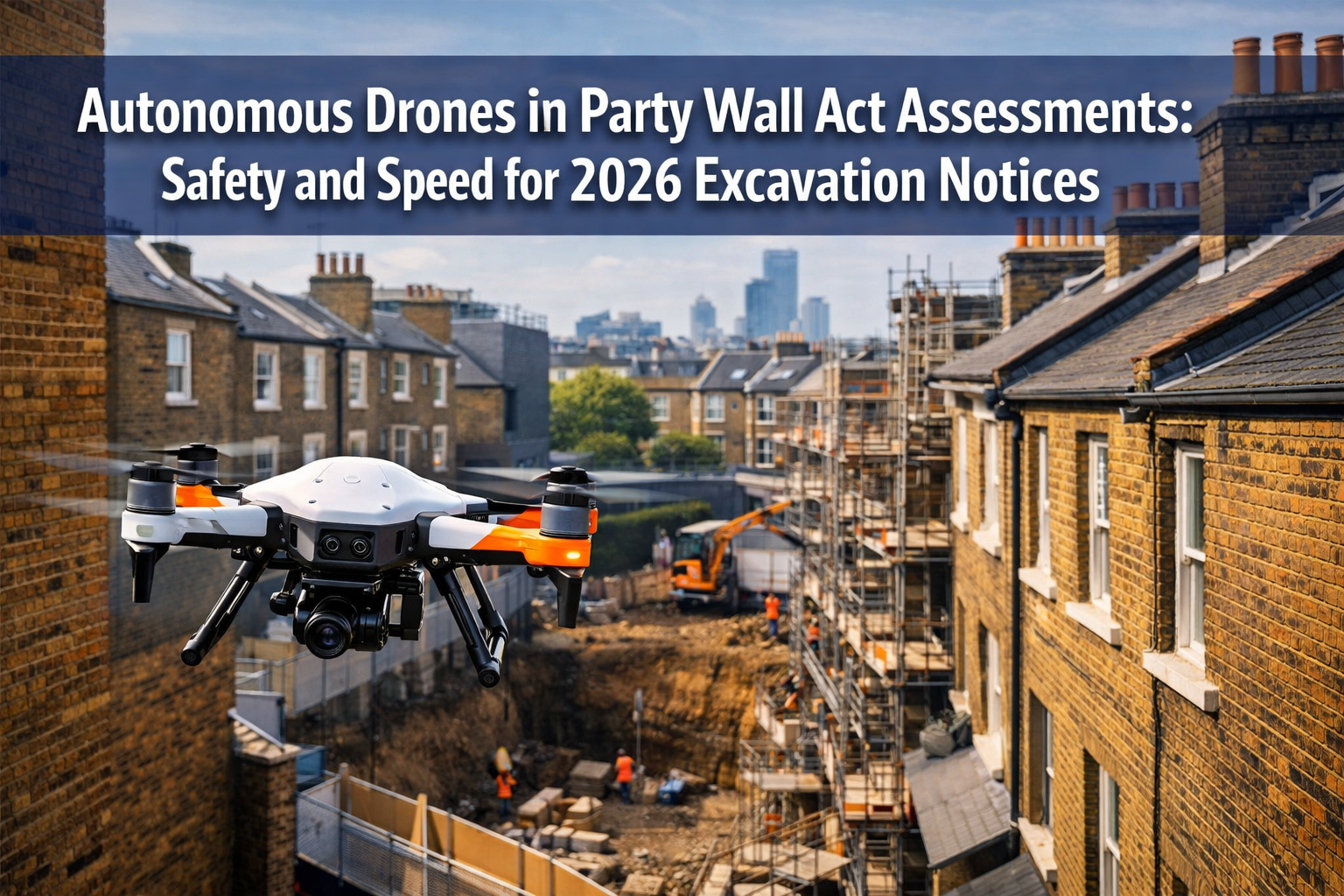
When excavation work begins in densely packed London neighborhoods, the traditional methods of surveying party walls and boundaries can be slow, risky, and expensive. In 2026, Autonomous Drones in Party Wall Act Assessments: Safety and Speed for 2026 Excavation Notices are transforming how surveyors capture critical boundary data, particularly for Section 6 notices that govern excavation near neighboring properties. These unmanned aerial systems eliminate the need for scaffolding, reduce safety risks, and deliver precise measurements in a fraction of the time—all while integrating seamlessly with digital twin technology for award validation.
The convergence of autonomous flight technology, artificial intelligence, and regulatory compliance is creating unprecedented opportunities for property owners, surveyors, and construction professionals. This comprehensive guide explores how drone-enabled remote surveying is revolutionizing party wall notices and excavation assessments across the UK.
Key Takeaways
✅ Autonomous drones eliminate scaffolding risks during Section 6 excavation notice surveys, capturing boundary data remotely without endangering personnel
✅ AI-powered processing converts drone imagery into precise 3D models and digital twins within hours, accelerating Party Wall Award validation timelines
✅ Regulatory compliance in 2026 requires CAA-approved operations, but BVLOS (Beyond Visual Line of Sight) waivers are increasingly accessible for urban surveying applications [1]
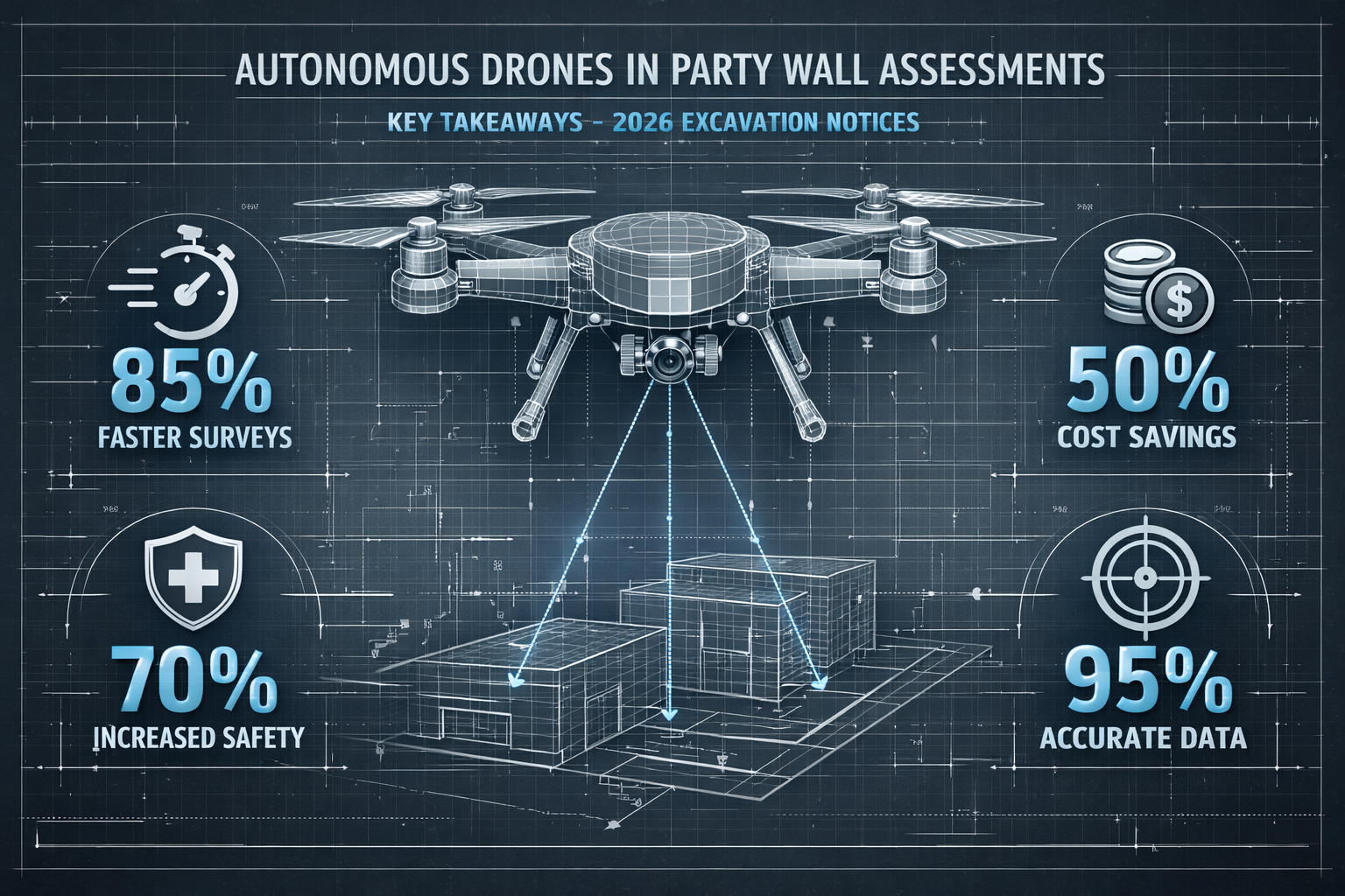
✅ Cost savings of 40-60% compared to traditional surveying methods, with dramatic reductions in project delays and safety incidents
✅ Integration with existing workflows allows surveyors to maintain compliance with the Party Wall etc. Act 1996 while leveraging cutting-edge technology
Understanding Section 6 Excavation Notices and Traditional Challenges
The Party Wall etc. Act 1996 establishes clear requirements when building owners plan excavation work within specified distances of neighboring structures. Section 6 notices must be served when excavation will occur:
- Within 3 meters of a neighbor's structure and will go deeper than their foundations
- Within 6 meters of a neighbor's structure and will cut a line drawn at 45 degrees from the bottom of their foundations
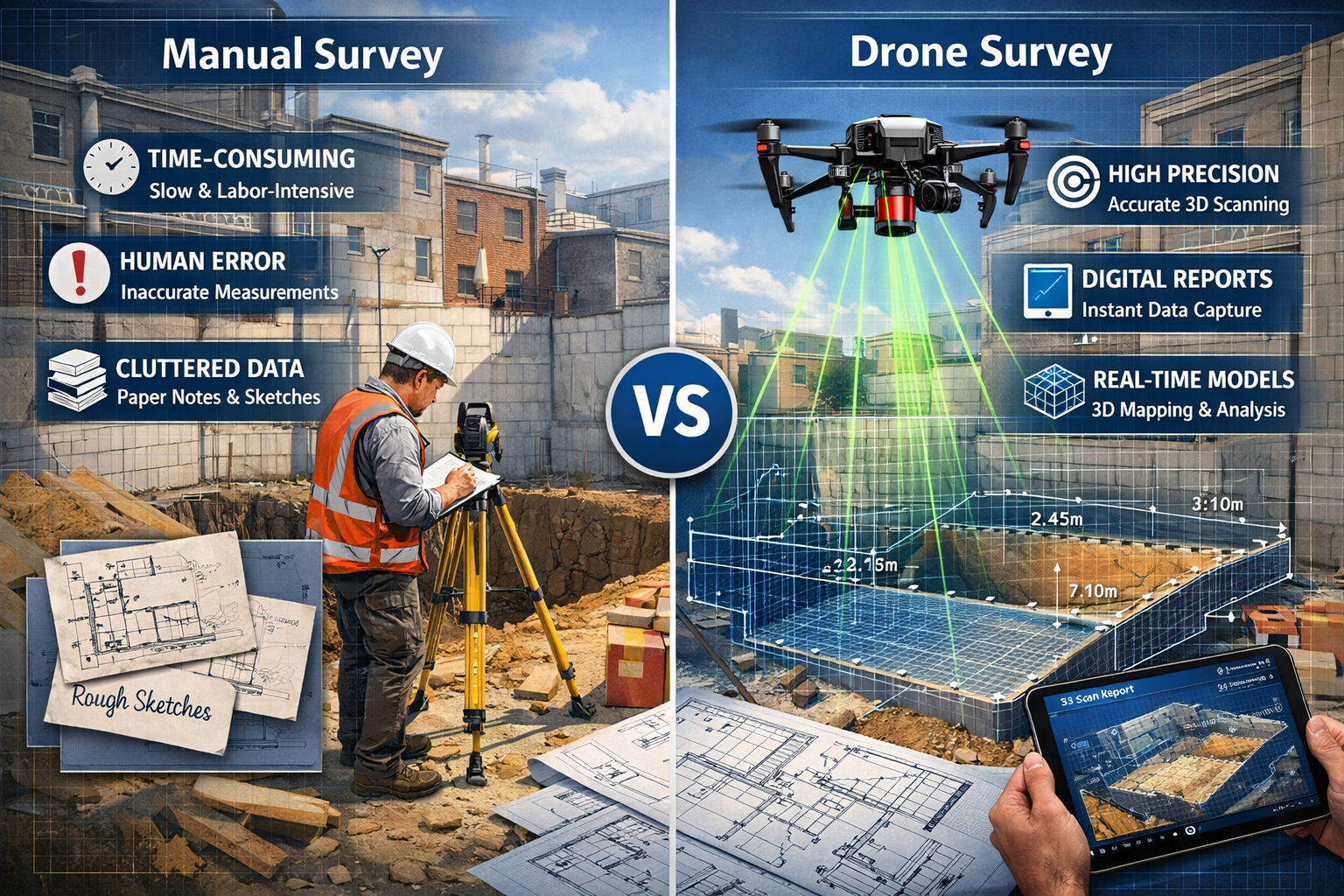
Traditional Survey Limitations
Conventional approaches to capturing pre-excavation condition data face significant obstacles in urban environments:
Safety Hazards 🚧
- Scaffolding installation near boundaries creates fall risks
- Surveyors working at height require extensive safety equipment
- Access to narrow passages between properties poses injury concerns
- Weather conditions frequently delay outdoor measurement work
Time Constraints ⏰
- Manual measurements of multi-story party walls can take several days
- Scheduling access with multiple property owners creates bottlenecks
- Photographic documentation requires numerous site visits
- Processing and compiling traditional survey data extends project timelines
Accuracy Issues 📐
- Human measurement error compounds across large structures
- Limited visual access to upper-story features
- Difficulty documenting roof lines and chimneys from ground level
- Incomplete baseline records lead to disputes during award validation
These challenges are particularly acute in areas like East London and Central London, where Victorian terraced housing creates complex boundary situations with minimal clearance between properties.
How Autonomous Drones Transform Party Wall Act Assessments
Autonomous drone technology addresses each traditional limitation through advanced sensors, intelligent flight systems, and rapid data processing capabilities that were unavailable just a few years ago.
Remote Boundary Data Capture Without Scaffolding
The most immediate benefit of drone-enabled surveying is the elimination of scaffolding requirements for boundary assessments. Modern autonomous systems equipped with high-resolution cameras and LiDAR sensors can capture comprehensive structural data while hovering safely between properties.
Key Capabilities:
| Feature | Traditional Method | Autonomous Drone Method |
|---|---|---|
| Access Height | Limited by ladder/scaffolding | Full building height access |
| Safety Risk | High (falls, equipment) | Minimal (remote operation) |
| Survey Duration | 2-4 days per property | 2-4 hours per property |
| Weather Dependency | Significant delays | Reduced (rapid deployment) |
| Data Completeness | Partial (access limitations) | Comprehensive (360° capture) |
| Personnel Required | 2-4 surveyors | 1 operator + 1 surveyor |
The integration of AI-powered autonomous flight systems has dramatically improved operational efficiency in 2026. According to recent industry analysis, drone surveying operations now leverage artificial intelligence for real-time obstacle detection and adaptive flight path optimization [1]. This advancement is particularly valuable in constrained urban environments where manual piloting would be challenging or impossible.
BVLOS Operations for Urban Surveying
Beyond Visual Line of Sight (BVLOS) operations represent a significant regulatory milestone for autonomous drones in party wall assessments. While traditional drone operations require the pilot to maintain visual contact, BVLOS waivers approved by the Civil Aviation Authority (CAA) enable drones to survey multiple properties along a terrace or street without repositioning the operator.
The commercial drone industry has seen increasing accessibility to BVLOS approvals in 2026, with streamlined application processes for qualified operators conducting infrastructure and property surveys [1]. This regulatory evolution directly benefits types of party wall works that involve multiple adjoining properties.
Precision Measurement and Digital Twin Integration
Perhaps the most transformative aspect of autonomous drones in party wall assessments is their ability to generate digital twins—precise 3D virtual replicas of physical structures. These digital models serve multiple purposes throughout the Party Wall Act compliance process:
Pre-Excavation Documentation 📊
- Millimeter-accurate baseline measurements of party walls
- Comprehensive photographic records with geospatial tagging
- Structural feature identification (cracks, settlement, weathering)
- Automated comparison against historical survey data
Award Validation ✅
- Digital twins enable rapid verification of proposed works against Party Wall Awards
- 3D models demonstrate compliance with agreed-upon specifications
- Virtual site inspections reduce the need for multiple physical visits
- Dispute resolution supported by objective measurement data
Post-Construction Verification 🔍
- Automated detection of structural changes or damage
- Precise quantification of any settlement or movement
- Evidence-based assessment of construction impact
- Streamlined claims processing if damage occurs
The strategic briefing on drone surveying for 2026 emphasizes that modern platforms can process captured data into actionable 3D models within hours rather than days [4], dramatically accelerating the timeline from initial notice to excavation commencement.
Safety Advantages and Regulatory Compliance in 2026
The safety benefits of autonomous drones extend beyond eliminating scaffolding risks. The technology addresses multiple hazard categories that have historically plagued construction and surveying operations.
Enhanced Operational Safety
Reduced Personnel Exposure 👷
- Surveyors remain at ground level during data collection
- No working at height requirements for boundary assessments
- Elimination of ladder and scaffolding-related injuries
- Reduced exposure to unstable structures during excavation
Environmental Hazard Mitigation 🌧️
- Rapid deployment minimizes weather-related risks
- Operations possible in conditions unsafe for manual surveying
- Reduced time spent in active construction zones
- Lower risk of falling debris incidents
The public safety sector has recognized these advantages, with 2026 marking a transition year for UAS (Unmanned Aircraft Systems) adoption across emergency services and infrastructure assessment [6]. The same safety principles apply directly to party wall surveying applications.
Airspace Security and Counter-UAS Considerations
As drone adoption accelerates, airspace security has become an increasingly important consideration. Security teams must now account for both authorized survey drones and potential unauthorized incursions near construction sites [2].
For party wall surveyors operating autonomous drones in 2026, this reality requires:
- Registration and authorization with the CAA for all commercial operations
- Geofencing compliance to respect restricted airspace zones
- Transponder technology enabling identification and tracking
- Coordination protocols with neighboring property owners regarding flight operations
- Insurance coverage specific to drone operations near occupied structures
The emerging regulatory framework for autonomous aircraft continues to evolve, with industry panels exploring standardized rules for drone operations in complex urban environments [3]. Surveyors must stay current with these developments to maintain compliance.
CAA Regulations and Professional Standards
The Civil Aviation Authority maintains comprehensive requirements for commercial drone operations in the UK. For party wall assessment applications in 2026, key regulatory considerations include:
Operator Certification 📜
- A2 Certificate of Competency (A2 CofC) for operations near people
- General Visual Line of Sight Certificate (GVC) for standard surveys
- Enhanced permissions for BVLOS operations in urban areas
- Operator ID registration and annual renewal
Operational Limitations ⚠️
- Maximum altitude restrictions (typically 120m/400ft)
- Distance requirements from uninvolved persons
- Restricted zones near airports and sensitive sites
- Weather minimums (wind speed, visibility, precipitation)
Documentation Requirements 📋
- Operations manual specific to surveying applications
- Risk assessments for each operational environment
- Flight planning and notification procedures
- Incident reporting protocols
Professional bodies like the Royal Institution of Chartered Surveyors (RICS) are developing guidance documents that integrate drone technology with traditional party wall surveying standards, ensuring that technological innovation complements rather than compromises professional obligations.
Speed and Efficiency Gains for 2026 Excavation Projects
The time savings delivered by autonomous drones create cascading benefits throughout the excavation notice process, from initial assessment through final validation.
Accelerated Survey Timelines
Traditional party wall surveys for excavation projects typically follow this timeline:
- Initial site visit and access coordination: 3-5 days
- Scaffolding installation (if required): 2-3 days
- Manual measurement and photography: 2-4 days
- Data processing and report generation: 5-7 days
- Scaffolding removal: 1-2 days
Total traditional timeline: 13-21 days
Autonomous drone-enabled surveys compress this dramatically:
- Flight planning and CAA notifications: 1-2 days
- On-site data capture: 2-4 hours
- AI-powered processing and 3D model generation: 4-8 hours
- Automated report generation: 1-2 days
Total drone-enabled timeline: 3-5 days
This represents a 70-80% reduction in survey duration, enabling excavation work to commence significantly faster while maintaining comprehensive documentation standards required by party wall act notices.
Cost-Benefit Analysis
The financial advantages of drone technology extend beyond direct labor savings:
Direct Cost Reductions 💰
- Elimination of scaffolding rental (£800-£2,000 per property)
- Reduced surveyor time on-site (60-70% reduction)
- Lower insurance premiums due to reduced risk exposure
- Decreased equipment transportation costs
Indirect Financial Benefits 📈
- Faster project commencement reduces financing costs
- Reduced risk of construction delays and penalties
- Lower dispute resolution costs due to comprehensive documentation
- Enhanced ability to serve multiple properties efficiently
Investment Requirements 💵
- Commercial-grade survey drone: £8,000-£25,000
- Processing software licenses: £2,000-£5,000 annually
- Operator training and certification: £1,500-£3,000
- Insurance coverage: £1,200-£2,500 annually
For surveying practices handling multiple party wall projects annually, the return on investment typically occurs within 12-18 months. Firms operating in high-density areas like North London or South London see particularly strong benefits due to the concentration of terraced properties requiring Section 6 assessments.
Highway and Infrastructure Applications
The efficiency gains demonstrated in party wall assessments extend to related infrastructure surveying applications. Drone technology has proven particularly valuable for highway planning and road surveys in 2026, where rapid data collection minimizes traffic disruption [5].
These same principles apply when excavation projects involve:
- Utility mapping near party wall boundaries
- Drainage assessment affecting multiple properties
- Access road documentation for construction vehicles
- Temporary works verification during excavation phases
Practical Implementation: Getting Started with Drone-Enabled Assessments
For property owners, building professionals, and surveyors considering autonomous drone technology for party wall assessments, several practical steps facilitate successful implementation.
Selecting Appropriate Drone Technology
Not all drones are suitable for party wall surveying applications. Key specifications to prioritize include:
Sensor Capabilities 📷
- High-resolution camera (minimum 20MP, preferably 45MP+)
- LiDAR or photogrammetry capability for 3D modeling
- Obstacle avoidance sensors (forward, backward, lateral, upward, downward)
- GPS/GNSS precision positioning (RTK preferred)
Flight Performance ✈️
- Stability in moderate wind conditions (15-20 mph capability)
- Sufficient flight time (25-30 minutes minimum)
- Quiet operation for residential environments
- Compact size for maneuvering between properties
Autonomous Features 🤖
- Programmable flight paths for repeatable surveys
- Automated capture modes for comprehensive coverage
- Real-time obstacle detection and avoidance
- Return-to-home safety protocols
Data Management 💾
- Onboard storage capacity (minimum 128GB)
- Real-time data transmission capability
- Compatible file formats for processing software
- Secure data encryption for client confidentiality
Popular platforms for professional surveying in 2026 include the DJI Mavic 3 Enterprise series, Autel EVO II Pro RTK, and specialized surveying drones from manufacturers like senseFly and Wingtra.
Integration with Existing Party Wall Workflows
Successful drone adoption requires thoughtful integration with established party wall procedures rather than wholesale replacement of proven processes.
Pre-Survey Phase 📋
- Include drone operations in initial client consultations
- Obtain explicit consent for aerial photography from all parties
- Coordinate flight operations with party wall notice timelines
- Complete risk assessments specific to each site
Survey Execution 🚁
- Conduct traditional ground-level observations alongside drone capture
- Maintain professional surveyor oversight of all data collection
- Document flight parameters and environmental conditions
- Capture redundant data to ensure completeness
Post-Survey Processing 🖥️
- Integrate drone-derived measurements with traditional survey data
- Apply professional judgment to automated outputs
- Generate schedule of condition documents incorporating 3D models
- Maintain secure archival of raw drone data for future reference
Award and Compliance ⚖️
- Include digital twin access provisions in party wall agreements
- Specify drone re-survey protocols for post-construction verification
- Address data ownership and access rights in award documents
- Establish dispute resolution procedures utilizing 3D evidence
Training and Professional Development
Effective use of autonomous drones for party wall assessments requires both technical drone operation skills and deep understanding of party wall legislation and surveying principles.
Essential Training Components 🎓
- CAA-approved drone pilot training and certification
- Photogrammetry and LiDAR processing software proficiency
- Party Wall Act interpretation and application
- Risk assessment and safety management
- Client communication regarding new technology
Professional development resources include:
- RICS continuing professional development (CPD) courses on emerging surveying technology
- CAA-approved training organizations (ATOs) offering commercial drone certifications
- Manufacturer-specific training for surveying platforms
- Industry conferences focusing on construction technology integration
Case Studies: Real-World Applications in Dense Urban Environments
The theoretical advantages of autonomous drones become tangible when examining actual party wall assessment projects completed in 2026.
Victorian Terrace Excavation in East London
A basement excavation project involving five adjoining Victorian properties in Hackney required comprehensive Section 6 notices and pre-construction surveys. Traditional approaches would have necessitated scaffolding installation across all five properties, with estimated costs exceeding £12,000 and survey duration of 15-20 days.
Drone-Enabled Solution:
- Single-day flight operations captured all five party walls and boundaries
- LiDAR processing generated millimeter-accurate digital twins within 24 hours
- Automated comparison identified three previously undocumented cracks requiring attention
- Total survey cost: £4,200 (65% savings)
- Timeline: 4 days from initial flight to final report
The comprehensive 3D documentation proved invaluable when one adjoining owner raised concerns about potential structural impact, as the digital twin enabled virtual demonstration of the proposed excavation's relationship to existing foundations.
Commercial Development in Central London
A mixed-use development in Westminster involved excavation within 3 meters of multiple commercial and residential properties, requiring coordination with over 20 adjoining owners. The complexity of access arrangements and varying building heights presented significant challenges for traditional surveying.
Autonomous Drone Advantages:
- BVLOS operation surveyed entire block perimeter in single session
- Captured comprehensive roof condition data impossible from ground level
- Identified drainage issues affecting multiple properties
- Generated unified digital twin enabling holistic impact assessment
- Facilitated virtual site tours for remote adjoining owners
The project demonstrated particular value in enabling party wall awards to proceed despite several adjoining owners being overseas investors with limited availability for site visits.
Challenges and Lessons Learned
Real-world implementation has also revealed important considerations:
Technical Challenges ⚠️
- Dense urban environments occasionally create GPS signal interference
- Narrow passages between properties require manual piloting skills despite autonomous capabilities
- Weather windows for optimal data capture can be limited
- Processing large datasets requires significant computing resources
Stakeholder Management 🤝
- Some adjoining owners express privacy concerns regarding aerial photography
- Clear communication about drone operations prevents misunderstandings
- Transparency about data capture and usage builds trust
- Traditional survey methods remain necessary for interior party wall assessments
Future Developments and Emerging Technologies
The trajectory of autonomous drone technology suggests continued advancement in capabilities relevant to party wall assessments beyond 2026.
AI and Machine Learning Integration
Artificial intelligence is already transforming drone surveying through automated flight planning and obstacle avoidance [1]. Future developments will likely include:
Predictive Analysis 🔮
- AI-powered identification of structural vulnerabilities before excavation
- Automated risk scoring for proposed works
- Machine learning models predicting settlement patterns
- Intelligent recommendations for protective measures
Automated Compliance Checking ✓
- AI comparison of proposed works against Party Wall Act requirements
- Automated generation of compliant notice documents
- Real-time validation of survey completeness
- Intelligent flagging of potential dispute triggers
Enhanced Sensor Technologies
Emerging sensor capabilities will expand the scope of drone-enabled assessments:
Thermal Imaging 🌡️
- Detection of moisture ingress in party walls
- Identification of insulation gaps affecting thermal performance
- Assessment of heating system impacts on shared structures
Ground-Penetrating Radar 📡
- Non-invasive foundation depth verification
- Underground utility mapping near excavation zones
- Soil composition analysis affecting excavation methodology
Structural Health Monitoring 🏗️
- Vibration sensors detecting micro-movements during construction
- Continuous monitoring throughout excavation phases
- Automated alerts for concerning structural changes
Regulatory Evolution
The regulatory framework governing autonomous drones continues to mature, with implications for party wall surveying:
- Standardized approval processes for urban BVLOS operations [3]
- Integration of drone operations with digital planning systems
- Streamlined notification procedures for routine surveying applications
- Enhanced data privacy protections for aerial imagery
Conclusion: Embracing Innovation While Maintaining Professional Standards
Autonomous Drones in Party Wall Act Assessments: Safety and Speed for 2026 Excavation Notices represent a genuine technological advancement that addresses longstanding challenges in property surveying. The elimination of scaffolding risks, dramatic acceleration of survey timelines, and integration with digital twin technology create compelling advantages for all stakeholders in the party wall process.
However, successful implementation requires more than simply purchasing a drone and launching it between properties. Professional surveyors must:
✅ Maintain rigorous compliance with both CAA regulations and Party Wall Act requirements
✅ Integrate technology thoughtfully with established professional practices and judgment
✅ Communicate transparently with property owners about drone operations and data usage
✅ Invest in training that combines technical drone operation skills with deep party wall expertise
✅ Recognize limitations and maintain traditional surveying capabilities for situations where drones are inappropriate
For property owners planning excavation work, engaging surveyors who leverage autonomous drone technology can deliver significant benefits in terms of cost, timeline, and documentation quality. When evaluating service providers, consider asking about:
- CAA certifications and insurance coverage for drone operations
- Experience with digital twin integration in party wall assessments
- Approach to combining traditional and drone-enabled surveying methods
- Data security and privacy protection protocols
- Post-construction verification capabilities using baseline 3D models
The construction industry's transition toward digital workflows and autonomous systems is accelerating in 2026 [6]. Party wall surveying is no exception to this trend. By embracing these innovations while maintaining the professional standards and neighbor-focused approach that have always characterized quality party wall work, surveyors can deliver superior outcomes for building owners and adjoining owners alike.
Next Steps for Implementation
For Building Owners:
- Discuss drone surveying options when selecting a party wall surveyor
- Include drone operation provisions in initial project planning
- Communicate proactively with neighbors about technology use
- Request digital twin access for future reference
For Surveyors:
- Evaluate drone platforms suitable for party wall applications
- Pursue CAA certification and professional training
- Develop risk assessment templates for urban drone operations
- Establish partnerships with processing software providers
- Update client engagement materials to explain technology benefits
For Adjoining Owners:
- Understand your rights regarding aerial photography of your property
- Request detailed information about drone operations near your home
- Ask about data retention and privacy protections
- Consider benefits of comprehensive documentation for future reference
The convergence of autonomous flight technology, artificial intelligence, and traditional surveying expertise is creating unprecedented opportunities to conduct party wall assessments more safely, quickly, and comprehensively than ever before. As the technology continues to mature and regulatory frameworks evolve, drone-enabled surveying will increasingly become the standard approach for Section 6 excavation notices and other party wall works across the UK's dense urban environments.
References
[1] Drone Surveying Ai Integration Bvlos Waiver – https://www.commercialuavnews.com/drone-surveying-ai-integration-bvlos-waiver
[2] The New Airspace Risk What Security Teams Need To Know About Drone Threats 2026 – https://www.droneshield.com/blog/the-new-airspace-risk-what-security-teams-need-to-know-about-drone-threats-2026
[3] Panel Explores Drone Autonomous Aircraft Rules – https://www.ainonline.com/aviation-news/aerospace/2026-03-10/panel-explores-drone-autonomous-aircraft-rules
[4] Webinar The State Of Drone Surveying A Strategic Briefing For 2026 – https://www.aerotas.com/blog/webinar-the-state-of-drone-surveying-a-strategic-briefing-for-2026
[5] Drone Road Surveys Highway Planning 2026 – https://birdseyeaerialdrones.com/drone-road-surveys-highway-planning-2026/
[6] Public Safety Uas In 2026 A Year Of Transition Security And Innovation – https://www.autonomyglobal.co/public-safety-uas-in-2026-a-year-of-transition-security-and-innovation/