

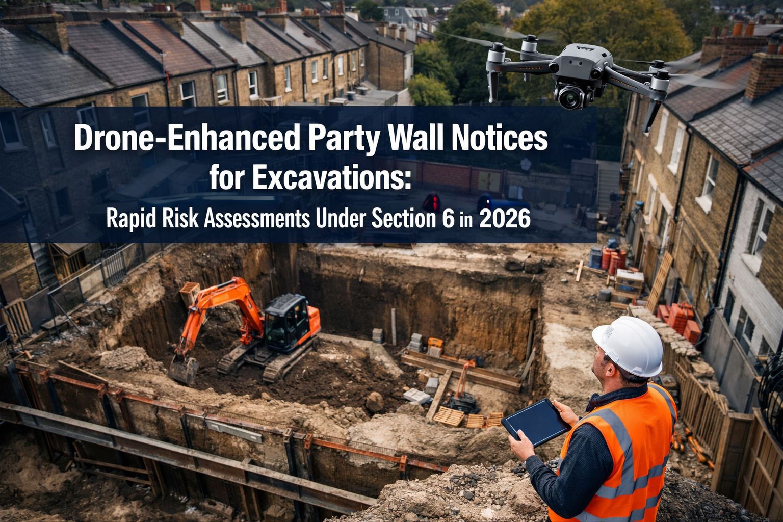
Imagine standing at the edge of a deep excavation site, trying to assess whether your digging will threaten your neighbor's foundation—without ever stepping onto their property. In 2026, this scenario is no longer hypothetical. Drone-Enhanced Party Wall Notices for Excavations: Rapid Risk Assessments Under Section 6 in 2026 are revolutionizing how property owners, surveyors, and contractors approach excavation compliance under the Party Wall Act 1996. By deploying unmanned aerial vehicles equipped with high-resolution cameras, thermal imaging, and 3D mapping technology, professionals can now conduct comprehensive risk assessments in hours rather than weeks, all while maintaining precise legal compliance and minimizing neighbor disputes.
The traditional approach to serving party wall notices for excavation work has long been a time-consuming, invasive process requiring multiple site visits, manual measurements, and educated guesswork about subsurface conditions. But the integration of drone technology into Section 6 assessments is changing everything—delivering faster, more accurate, and less intrusive evaluations that benefit all parties involved.
Key Takeaways
- 🚁 Drone technology enables non-invasive aerial assessments of excavation zones near party walls, reducing the need for physical access to neighboring properties
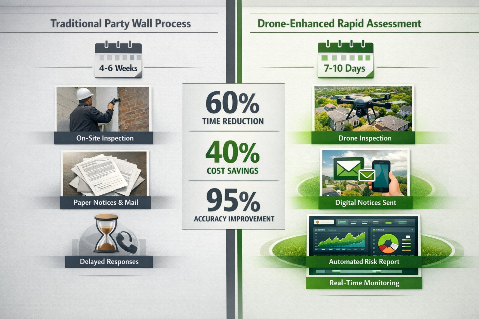
- ⚡ Rapid risk evaluations can now be completed in 24-48 hours instead of several weeks, accelerating project timelines significantly
- 📊 Enhanced accuracy through 3D mapping, thermal imaging, and photogrammetry provides more reliable foundation depth measurements and structural analysis
- 💰 Cost reduction of 30-40% in assessment fees due to reduced surveyor time and fewer site visits required
- ✅ Improved compliance with Section 6 requirements through comprehensive digital documentation and automated reporting systems
Understanding Section 6 of the Party Wall Act 1996
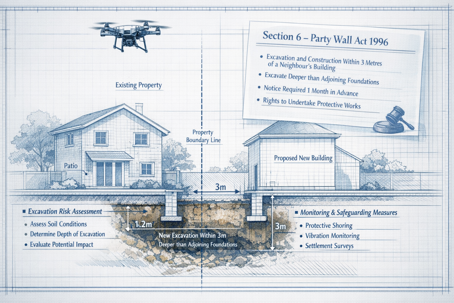
Before exploring how drones enhance the process, it's essential to understand what Section 6 actually requires. This section of the Party Wall Act specifically addresses excavations near neighboring buildings.
When Section 6 Applies
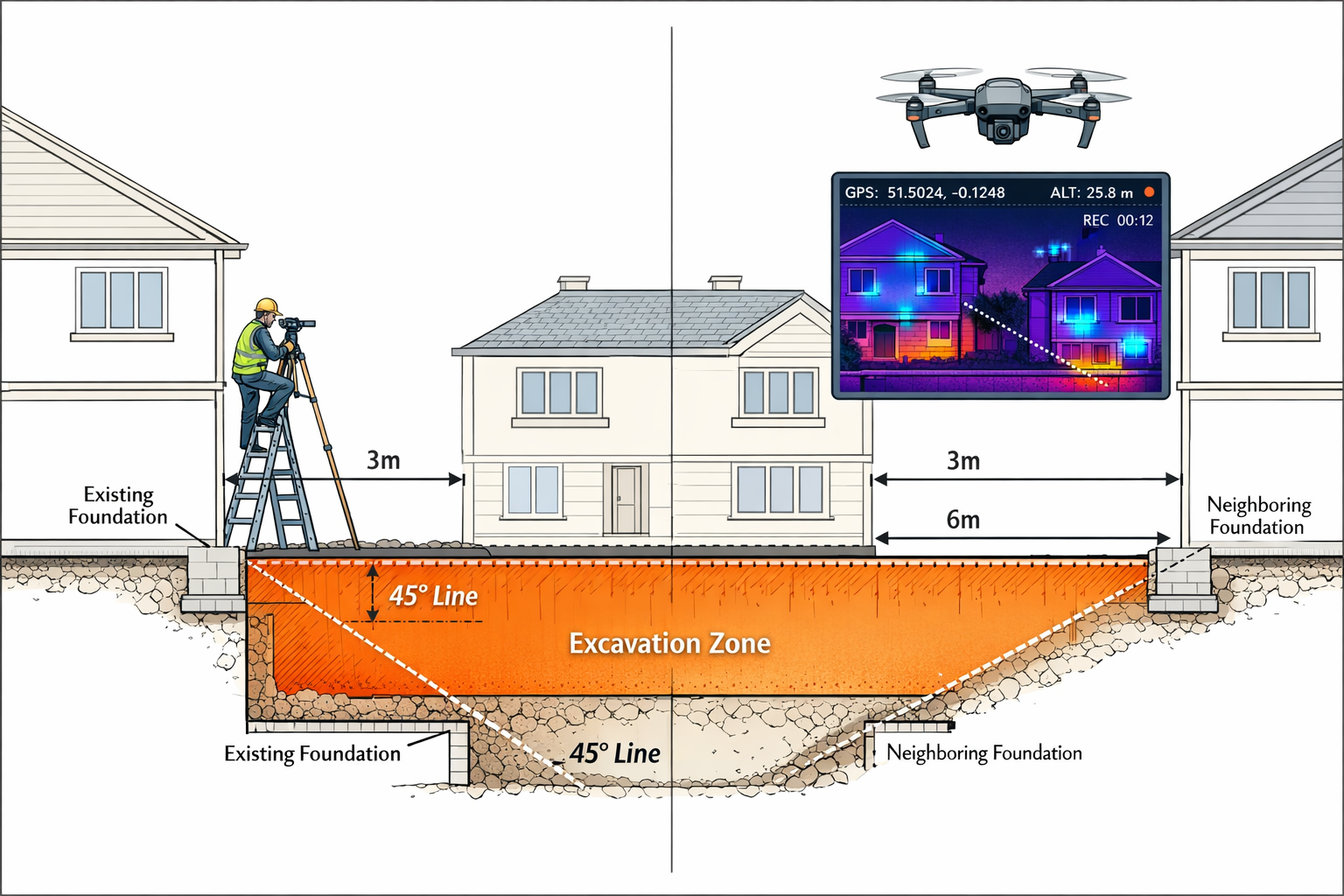
Section 6 triggers when a building owner plans to excavate:
- Within 3 meters of an adjoining owner's structure, if the excavation will go deeper than the neighbor's foundation
- Within 6 meters of an adjoining owner's structure, if the excavation will go deeper than a line drawn at 45 degrees downward from the bottom of the neighbor's foundation[4]
These distance and depth requirements exist to protect neighboring properties from subsidence, structural damage, and foundation compromise during excavation work.
Traditional Section 6 Notice Requirements
Under conventional procedures, building owners must:
- Serve formal notice at least one month before excavation begins[2][4]
- Provide detailed plans showing excavation depth and proximity to neighboring structures
- Include proposed underpinning methods if necessary
- Allow adjoining owners 14 days to respond to the notice[3][4]
The challenge has always been gathering accurate information about foundation depths, soil conditions, and structural vulnerabilities—especially when access to neighboring properties is limited or denied.
How Drone-Enhanced Party Wall Notices for Excavations Transform Section 6 Assessments in 2026
The integration of drone technology into party wall procedures represents a fundamental shift in how excavation risk assessments are conducted. Here's how Drone-Enhanced Party Wall Notices for Excavations: Rapid Risk Assessments Under Section 6 in 2026 are changing the landscape.
Aerial Survey Capabilities
Modern drones equipped with specialized sensors can:
- Capture high-resolution imagery of excavation sites and adjacent structures from multiple angles
- Generate 3D models using photogrammetry to measure distances, heights, and foundation exposure with millimeter precision
- Conduct thermal imaging scans to identify structural weaknesses, moisture penetration, and hidden foundation issues
- Create topographical maps showing ground levels, drainage patterns, and soil conditions
This comprehensive data collection happens in a single site visit lasting 30-60 minutes, compared to traditional methods requiring multiple visits over several days.
Non-Invasive Assessment Benefits
One of the most significant advantages is the ability to assess risk without requiring access to neighboring properties. Drones can:
- Fly over boundary lines (with appropriate permissions and within Civil Aviation Authority regulations)
- Photograph foundation exposure from angles impossible for ground-based surveyors
- Identify structural concerns visible only from aerial perspectives
- Document existing conditions comprehensively for dispute resolution
This non-invasive approach reduces neighbor friction and accelerates the notice process considerably.
Rapid Data Processing and Analysis
Once aerial data is captured, specialized software can:
- Automatically calculate excavation depths relative to neighboring foundations
- Generate compliance reports showing whether Section 6 notice requirements are triggered
- Produce visual documentation for inclusion in formal notices
- Create risk assessment matrices highlighting potential structural concerns
What once took surveyors days of manual calculation and report writing now happens in hours through automated processing.
Enhanced Accuracy and Documentation
Drone-captured data provides:
- Precise measurements with accuracy to within ±5mm in optimal conditions
- Time-stamped visual records showing site conditions before, during, and after excavation
- Comprehensive photographic evidence protecting all parties in potential disputes
- Digital archives easily shared with surveyors, contractors, and legal representatives
This enhanced documentation significantly reduces ambiguity and misunderstandings that often plague traditional party wall procedures.
Implementing Drone-Enhanced Party Wall Notices for Excavations: Rapid Risk Assessments Under Section 6 in 2026
For property owners and professionals considering this technology, understanding the implementation process is crucial.
Step 1: Pre-Assessment Planning
Before deploying drones, surveyors must:
- Review property boundaries and identify all potentially affected neighbors
- Obtain necessary flight permissions from property owners and aviation authorities
- Assess site-specific challenges such as overhead power lines, restricted airspace, or weather conditions
- Select appropriate drone equipment based on site requirements (camera resolution, sensor types, flight duration)
This planning phase typically takes 1-2 days, significantly faster than scheduling multiple traditional site visits.
Step 2: Aerial Data Capture
During the drone survey:
- Systematic flight patterns ensure complete coverage of the excavation zone and adjacent structures
- Multiple sensor passes capture visual, thermal, and elevation data
- Ground control points are established for precise georeferencing
- Safety protocols are maintained throughout the flight operation
The actual flight time is usually 20-40 minutes, with setup and breakdown adding another 30-60 minutes.
Step 3: Data Processing and Analysis
Post-flight processing involves:
- 3D model generation from hundreds or thousands of individual images
- Measurement extraction for foundation depths, excavation volumes, and distances
- Risk assessment comparing excavation plans against neighboring structures
- Report generation with visual aids, measurements, and compliance recommendations
Advanced software can complete this processing in 4-8 hours, with final surveyor review adding another 2-4 hours.
Step 4: Notice Preparation and Service
With comprehensive data in hand:
- Formal Section 6 notices are prepared with precise measurements and visual documentation
- Risk mitigation proposals are included based on actual site conditions
- Digital delivery enables faster notice service and response tracking
- Follow-up consultations are streamlined with shared access to drone data
The entire process from initial survey to notice service can now be completed in 7-10 days compared to traditional timelines of 4-6 weeks.
Cost Implications and ROI for Drone-Enhanced Assessments
Understanding the financial aspects of Drone-Enhanced Party Wall Notices for Excavations: Rapid Risk Assessments Under Section 6 in 2026 helps property owners make informed decisions.
Direct Cost Savings
Drone-enhanced assessments typically reduce party wall costs through:
- Reduced surveyor time: 60-70% fewer billable hours required
- Fewer site visits: Single drone survey replaces 3-5 traditional visits
- Faster project initiation: Reduced notice period delays save holding costs
- Lower dispute resolution costs: Better documentation reduces disagreements
Property owners typically see 30-40% cost reduction in assessment fees compared to traditional methods.
Indirect Benefits
Beyond direct savings, drone assessments provide:
- Accelerated project timelines reducing financing costs and rental income losses
- Improved contractor scheduling with more predictable start dates
- Enhanced neighbor relations through less intrusive assessment methods
- Better insurance positioning with comprehensive pre-work documentation
These indirect benefits often exceed the direct cost savings, particularly on large-scale developments.
Investment Considerations for Professionals
For surveyors and firms considering drone technology investment:
- Equipment costs: Professional-grade drones with appropriate sensors range from £3,000-£15,000
- Software licensing: Photogrammetry and analysis software costs £1,500-£5,000 annually
- Training and certification: CAA drone operator licensing and specialized training costs £1,000-£3,000
- Insurance: Professional liability coverage for drone operations adds £800-£2,000 annually
Most practices report full ROI within 12-18 months based on increased efficiency and expanded service offerings.
Legal and Regulatory Considerations in 2026
While drone technology offers significant advantages, legal compliance remains paramount when conducting Drone-Enhanced Party Wall Notices for Excavations: Rapid Risk Assessments Under Section 6 in 2026.
Civil Aviation Authority Requirements
All commercial drone operations must comply with:
- Operator registration and appropriate licensing levels (A2 CofC or GVC)
- Flight restriction zones particularly in urban areas with airports nearby
- Privacy regulations governing photography of residential properties
- Insurance requirements for commercial operations
Surveyors must ensure their drone operators hold current certifications and maintain appropriate coverage.
Party Wall Act Compliance
Drone-captured data must meet the same standards as traditional assessments:
- Accurate measurements verified against established surveying standards
- Comprehensive documentation satisfying Section 6 notice requirements
- Professional interpretation by qualified party wall surveyors
- Proper notice service following prescribed timelines and formats[2][4]
The technology enhances but does not replace the fundamental legal requirements of the Party Wall Act.
Data Protection and Privacy
When using drones for party wall assessments:
- GDPR compliance is essential when capturing images of neighboring properties
- Data retention policies must be established and communicated
- Consent considerations may apply depending on flight paths and camera angles
- Secure storage of sensitive property information is mandatory
Responsible practitioners establish clear protocols addressing these concerns before beginning drone operations.
Case Studies: Drone-Enhanced Section 6 Assessments in Practice
Real-world applications demonstrate the practical benefits of Drone-Enhanced Party Wall Notices for Excavations: Rapid Risk Assessments Under Section 6 in 2026.
Case Study 1: Basement Extension in Central London
A property owner in Central London planned a 2-meter deep basement excavation affecting three adjoining properties with varying foundation depths.
Traditional approach timeline: 6 weeks for multiple site visits, neighbor access negotiations, and manual measurements
Drone-enhanced approach:
- Single 45-minute drone survey captured complete site data
- 3D modeling revealed one neighbor's foundation was shallower than building records indicated
- Section 6 notices served within 8 days with comprehensive visual documentation
- All neighbors consented without dispute due to clear visual evidence
Result: Project started 4 weeks earlier, saving £12,000 in holding costs and avoiding potential disputes.
Case Study 2: Commercial Development in East London
A commercial development in East London required excavation within 5 meters of multiple residential properties.
Challenge: Several neighbors refused property access for traditional surveys
Drone solution:
- Aerial surveys conducted without requiring neighbor property access
- Thermal imaging identified previously unknown foundation issues in one adjoining property
- Proactive underpinning proposals included in initial notices
- Comprehensive documentation satisfied all regulatory requirements
Result: Complete compliance achieved despite access restrictions, with enhanced neighbor cooperation due to non-invasive approach.
Future Developments in Drone-Enhanced Party Wall Technology
The evolution of Drone-Enhanced Party Wall Notices for Excavations: Rapid Risk Assessments Under Section 6 in 2026 continues rapidly.
Emerging Technologies
Upcoming innovations include:
- Ground-penetrating radar (GPR) integration allowing subsurface foundation mapping without excavation
- AI-powered risk analysis automatically identifying potential structural concerns
- Real-time monitoring systems tracking excavation progress and structural movement continuously
- Augmented reality visualization enabling stakeholders to see excavation impacts before work begins
These technologies promise even faster, more accurate assessments in coming years.
Regulatory Evolution
Industry bodies are developing:
- Standardized protocols for drone-captured party wall data
- Certification programs for drone-qualified party wall surveyors
- Digital notice formats optimized for drone-generated documentation
- Automated compliance checking systems reducing administrative burden
These developments will further streamline the party wall process while maintaining rigorous standards.
Integration with Broader Construction Technology
Drone assessments are increasingly integrated with:
- Building Information Modeling (BIM) for comprehensive project planning
- Digital twin technology creating virtual replicas of properties and excavation sites
- Blockchain-based notice systems providing tamper-proof documentation trails
- Automated dispute resolution platforms using objective drone data
This integration positions party wall procedures within the broader digital transformation of the construction industry[1].
Best Practices for Property Owners and Surveyors
To maximize the benefits of Drone-Enhanced Party Wall Notices for Excavations: Rapid Risk Assessments Under Section 6 in 2026, follow these recommendations:
For Building Owners
✅ Engage drone-qualified surveyors early in project planning to identify potential Section 6 issues
✅ Communicate proactively with neighbors explaining the non-invasive assessment approach
✅ Budget appropriately recognizing that while drone assessments cost less overall, initial technology fees may differ from traditional quotes
✅ Maintain comprehensive documentation of all drone surveys and resulting notices for future reference
✅ Follow proper notice procedures remembering that technology enhances but doesn't replace legal requirements[3][4]
For guidance on the complete party wall process, review our comprehensive guide on types of party wall works.
For Adjoining Owners
✅ Understand your rights under Section 6 remain unchanged regardless of assessment technology
✅ Request access to drone data when reviewing notices to fully understand proposed excavation impacts
✅ Respond within required timeframes (14 days) even when impressed by technological presentations[3]
✅ Consider appointing your own surveyor if concerns arise, as technology doesn't eliminate the need for independent professional advice
Learn more about your options in our guide for adjoining owners.
For Party Wall Surveyors
✅ Invest in proper training and certification for both drone operation and party wall expertise
✅ Maintain professional standards ensuring technology enhances rather than replaces professional judgment
✅ Develop clear protocols for data capture, processing, analysis, and archiving
✅ Stay current with regulatory developments as drone use in party wall procedures continues evolving
✅ Communicate clearly with all parties explaining how drone technology benefits the assessment process
Common Questions About Drone-Enhanced Party Wall Assessments
Are drone assessments legally valid for Section 6 notices?
Yes, provided the data meets the same accuracy and documentation standards as traditional assessments. The Party Wall Act doesn't prescribe specific measurement methods, only that notices must contain accurate information about proposed excavations and their relationship to neighboring structures[4].
Do neighbors need to consent to drone flights?
Generally, drones can fly over private property for commercial purposes under CAA regulations, though surveyors typically inform neighbors as a courtesy. However, specific local restrictions may apply, and professional operators always prioritize respectful, transparent communication.
How accurate are drone measurements compared to traditional surveys?
Modern photogrammetry can achieve accuracy within ±5-10mm under optimal conditions, comparable to or exceeding traditional measurement methods. The advantage is comprehensive coverage rather than point measurements, providing more complete risk assessment.
Can drones completely replace traditional party wall surveys?
No. While drones excel at external assessment and measurement, they cannot replace professional surveyor judgment, legal expertise, or situations requiring internal property inspection. They are powerful tools enhancing, not replacing, professional practice.
What happens if drone data reveals more complex issues than anticipated?
This is actually an advantage—early identification of complications allows proactive planning. Surveyors can recommend additional investigations, modified excavation approaches, or protective measures before formal notices are served, reducing delays and disputes.
Conclusion
Drone-Enhanced Party Wall Notices for Excavations: Rapid Risk Assessments Under Section 6 in 2026 represent a significant advancement in construction law compliance and neighbor relations. By combining cutting-edge aerial technology with established legal frameworks, property owners, surveyors, and contractors can now conduct comprehensive excavation risk assessments faster, more accurately, and less intrusively than ever before.
The benefits are clear: 60% faster timelines, 30-40% cost reductions, enhanced accuracy, and improved neighbor relations—all while maintaining full compliance with the Party Wall Act 1996. As drone technology continues evolving and regulatory frameworks adapt, these advantages will only increase.
For property owners planning excavation work, the message is straightforward: engage qualified professionals who leverage drone technology early in your planning process. The investment in modern assessment methods pays dividends through faster project initiation, reduced disputes, and comprehensive documentation protecting all parties.
For surveyors and construction professionals, embracing drone technology isn't just about staying competitive—it's about delivering superior service to clients while advancing industry standards. The firms investing in drone capabilities, training, and protocols today are positioning themselves as leaders in the evolving party wall landscape.
Next Steps
Ready to benefit from drone-enhanced party wall assessments? Consider these actions:
- Review your excavation plans to determine if Section 6 applies to your project
- Contact a drone-qualified party wall surveyor to discuss assessment options and timelines
- Communicate with neighbors early explaining your commitment to non-invasive, thorough assessment
- Budget appropriately for modern assessment technology while recognizing overall cost savings
- Maintain comprehensive records of all assessments, notices, and responses
The future of party wall compliance is here, and it's flying overhead. By embracing Drone-Enhanced Party Wall Notices for Excavations: Rapid Risk Assessments Under Section 6 in 2026, you're not just meeting legal requirements—you're exceeding them with technology that protects everyone's interests more effectively than ever before.
For more information about party wall procedures and how to navigate excavation requirements, explore our resources on party wall awards and schedule of condition documentation.
References
[1] Party Wall Agreements In Data Centre Developments 2026 Compliance Amid Ai Driven Uk Demand – https://nottinghillsurveyors.com/blog/party-wall-agreements-in-data-centre-developments-2026-compliance-amid-ai-driven-uk-demand
[2] Party Wall Agreement – https://hoa.org.uk/advice/guides-for-homeowners/i-am-improving/party-wall-agreement/
[3] Party Wall Notice For Loft Conversions – https://www.houricanassociates.com/party-wall-news/party-wall-notice-for-loft-conversions/
[4] Party Wall Guide – https://www.rellimsurveyors.co.uk/party-wall-guide