
When two property owners share a wall, precision matters. A difference of just a few millimeters can mean the difference between a smooth construction project and a costly legal dispute. In 2026, Millimeter-Accuracy Positioning Technology in Party Wall Awards: Reality Capture for Precision Shared Boundary Documentation is transforming how surveyors document shared boundaries, creating indisputable records that protect both building owners and their neighbors.
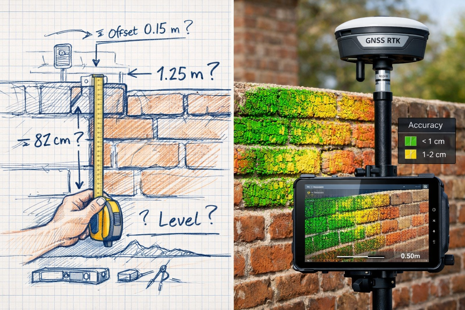
Traditional measuring methods—tape measures, hand-drawn sketches, and visual inspections—leave room for interpretation and error. Modern reality capture technologies, combined with advanced GNSS (Global Navigation Satellite System) positioning, now deliver centimeter-to-millimeter accuracy. These tools create comprehensive digital records that eliminate measurement ambiguity and reduce disputes before they escalate.
Key Takeaways
✅ Reality capture technologies like laser scanning and photogrammetry deliver millimeter-level accuracy for party wall documentation, far exceeding traditional measurement methods.
✅ GNSS RTK positioning provides centimeter-level accuracy for outdoor boundary surveys, creating georeferenced records that integrate seamlessly with legal documentation.
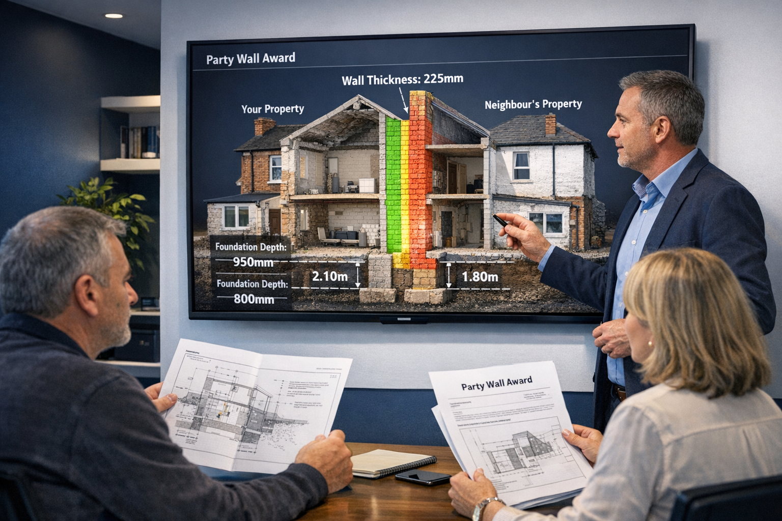
✅ 3D point cloud models serve as permanent, objective records in party wall awards, reducing disputes and protecting all parties involved.
✅ Digital documentation streamlines the party wall process, making it easier to demonstrate compliance and track changes over time.
✅ Cost-effectiveness improves as technology becomes more accessible, with long-term savings from reduced disputes and faster project approvals.
Understanding Millimeter-Accuracy Positioning Technology in Party Wall Awards
What Is Reality Capture Technology?
Reality capture refers to the process of digitally documenting physical spaces using advanced measurement technologies. For party wall surveyors, this means creating highly accurate 3D models of shared boundaries, structures, and surrounding properties. The two primary technologies driving this revolution are:
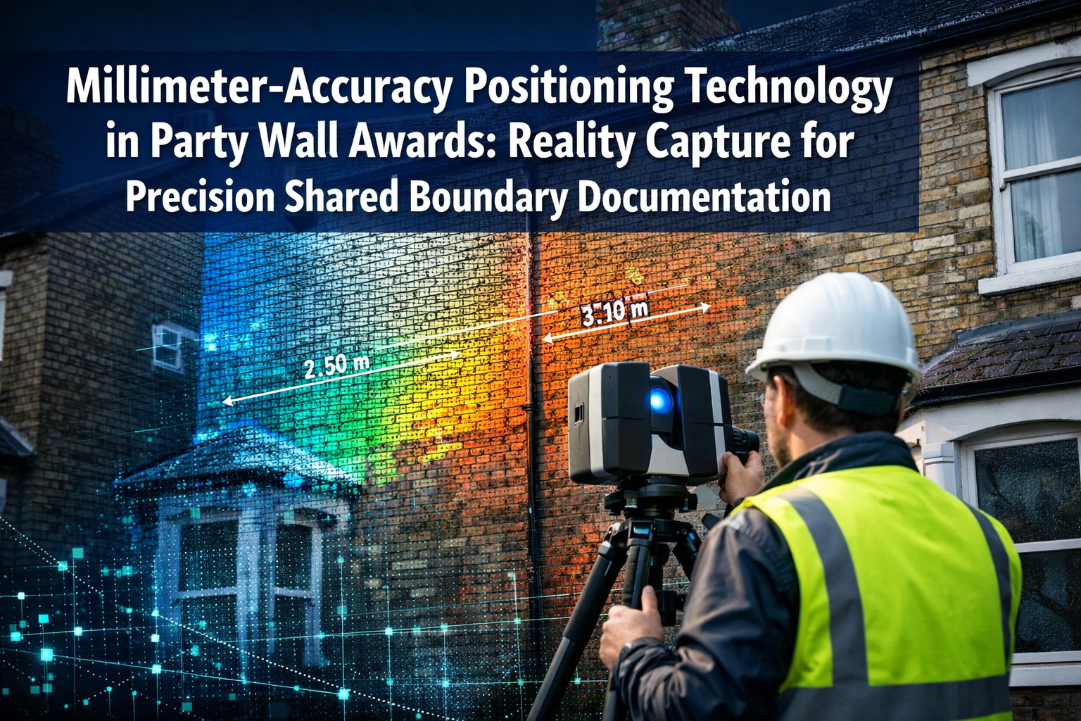
Laser Scanning (LiDAR) 📡
Laser scanners emit millions of laser pulses per second, measuring the distance to surfaces with millimeter precision. The result is a "point cloud"—a dense collection of three-dimensional coordinates that represent every surface detail. Modern terrestrial laser scanners can capture up to 2 million points per second with accuracy within ±2mm at 10 meters.
Photogrammetry 📸
This technique uses overlapping photographs taken from multiple angles to create accurate 3D models. Advanced software analyzes common features across images to calculate precise spatial coordinates. When properly executed, photogrammetry can achieve accuracy within 5-10mm for party wall documentation.
GNSS RTK Positioning 🛰️
Real-Time Kinematic (RTK) GNSS positioning uses satellite signals combined with ground-based correction stations to achieve centimeter-level accuracy. According to recent industry analysis, RTK systems now routinely deliver horizontal accuracy within ±8mm and vertical accuracy within ±15mm [3]. This technology is particularly valuable for outdoor boundary documentation and georeferencing party wall surveys to official property records.
How Technology Enhances Party Wall Documentation
The Party Wall etc. Act 1996 requires accurate documentation of existing conditions before construction work begins. Traditional methods involve:
- Hand measurements with tape measures (accuracy: ±5-10mm under ideal conditions)
- Written descriptions subject to interpretation
- Photographs without precise spatial context
- Sketches that may lack dimensional accuracy
Millimeter-accuracy positioning technology transforms this process by providing:
| Traditional Method | Reality Capture Method | Improvement |
|---|---|---|
| Manual tape measurements | Automated laser scanning | 10-50x faster data collection |
| ±10mm accuracy | ±2mm accuracy | 5x more precise |
| 2D sketches | Full 3D models | Complete spatial context |
| Static photographs | Interactive point clouds | Measurable from any angle |
| Subjective descriptions | Objective digital records | Eliminates interpretation disputes |
When preparing a schedule of condition, surveyors can now capture every crack, bulge, and surface irregularity with unprecedented detail. This comprehensive documentation protects both the building owner undertaking works and the adjoining owner whose property shares the boundary.
The Legal Value of Precision Documentation
Party wall disputes often arise from disagreements about:
- Pre-existing conditions: Did that crack exist before construction started?
- Boundary locations: Where exactly does one property end and another begin?
- Structural changes: Has the party wall shifted or settled during works?
- Damage claims: What damage, if any, resulted from the construction work?
Millimeter-accurate digital records provide objective, verifiable evidence that can resolve these disputes quickly. When both parties can view an interactive 3D model showing precise measurements and conditions, subjective disagreements become factual discussions. This transparency significantly reduces the likelihood of costly legal proceedings.
Many types of party wall works benefit from precision documentation, including excavations near boundaries, structural alterations to party walls, and new building work astride boundaries.
Implementing Millimeter-Accuracy Positioning Technology in Party Wall Awards: Reality Capture Workflows
Step-by-Step Reality Capture Process
1. Pre-Survey Planning 🗺️
Before deploying technology, surveyors must:
- Identify all party walls and shared boundaries requiring documentation
- Obtain access permissions from both building and adjoining owners
- Assess site conditions (lighting, access constraints, safety hazards)
- Select appropriate technology based on project requirements
2. Data Acquisition 📊
The surveyor visits the site with reality capture equipment:
- Laser scanning: Set up scanner at multiple positions to capture all surfaces without shadows or gaps. Each scan position takes 3-8 minutes depending on resolution requirements.
- GNSS positioning: Establish control points using RTK receivers for georeferencing. Modern equipment achieves centimeter-level accuracy within minutes of initialization [3].
- Photography: Capture high-resolution images for texture mapping and photogrammetric processing.
3. Data Processing 💻
Raw scan data requires processing to create usable models:
- Register (align) multiple scan positions into a unified coordinate system
- Remove noise and unwanted objects (vehicles, pedestrians, vegetation)
- Extract measurements, cross-sections, and elevation profiles
- Generate deliverables (3D models, floor plans, elevation drawings)
4. Documentation Integration 📋
Integrate reality capture data into party wall awards:
- Export precise measurements for written descriptions
- Include annotated images showing specific features
- Provide access to interactive 3D models for all parties
- Archive complete datasets for future reference
5. Ongoing Monitoring 🔍
For projects with extended timelines:
- Conduct periodic re-scans to document progress and changes
- Compare new scans against baseline to identify any movement or damage
- Update party wall records as work progresses
- Provide evidence of compliance with award conditions
Technology Selection Criteria
Not every party wall project requires the same level of technological sophistication. Consider these factors:
Project Complexity 🏗️
- Simple wall repairs: Photogrammetry or handheld laser distance meters may suffice
- Structural alterations: Terrestrial laser scanning provides comprehensive documentation
- Large-scale developments: Combination of GNSS, laser scanning, and drone photogrammetry
Budget Considerations 💰
Reality capture costs have decreased significantly as technology matures. While specialized equipment represents a substantial investment, many surveyors now offer these services at competitive rates. The cost of precision documentation often proves minimal compared to the expense of resolving measurement disputes. For guidance on managing expenses, see our article on how to keep party wall costs down.
Accuracy Requirements 🎯
- Boundary disputes: ±5-10mm accuracy typically sufficient
- Structural monitoring: ±2mm accuracy recommended
- Historic buildings: Sub-millimeter accuracy may be necessary for conservation work
Timeline Constraints ⏱️
Reality capture significantly accelerates data collection:
- Traditional survey of terraced house party wall: 4-6 hours
- Laser scan of same property: 45-90 minutes on-site
- Processing and deliverable preparation: Similar for both methods
The time savings become particularly valuable when documenting multiple properties or complex shared structures.
Common Applications in Party Wall Practice
Excavation and Foundation Work ⛏️
When building owners plan excavations within 3 or 6 meters of an adjoining property (as defined by the Act), precise documentation of existing conditions becomes critical. GNSS positioning establishes exact boundary locations, while laser scanning captures the current state of foundations, walls, and structures that might be affected by ground movement.
Structural Alterations 🔨
Modifications to party walls—removing chimney breasts, inserting beams, or creating openings—require detailed before-and-after documentation. 3D reality capture provides comprehensive evidence of pre-existing conditions and enables accurate comparison after works complete.
New Building on Boundary Lines 🏘️
Construction of new walls directly on property boundaries demands precision. Millimeter-accurate positioning ensures the new structure respects legal boundaries while providing clear documentation for party wall awards.
Dispute Resolution ⚖️
When disagreements arise about boundary locations, structural damage, or compliance with award conditions, objective 3D data provides compelling evidence. Interactive models allow all parties to examine the same information, facilitating faster resolution.
Benefits and Future of Precision Technology in Shared Boundary Documentation
Advantages for All Stakeholders
Building Owners 🏠
Property owners planning construction work benefit from:
- Protection against false claims: Comprehensive baseline documentation proves pre-existing conditions
- Faster approvals: Detailed, professional documentation expedites the party wall process
- Reduced disputes: Clear evidence minimizes disagreements with neighbors
- Compliance demonstration: Precise records show adherence to award conditions
Adjoining Owners 👥
Neighbors affected by party wall works gain:
- Objective evidence: Independent, accurate records of their property's condition
- Early damage detection: Comparison scans reveal any changes during construction
- Fair compensation: Precise documentation supports legitimate damage claims
- Peace of mind: Comprehensive monitoring protects their property interests
Party Wall Surveyors 📐
Professional surveyors adopting these technologies experience:
- Enhanced credibility: Cutting-edge tools demonstrate professional competence
- Reduced liability: Accurate documentation minimizes errors and omissions
- Efficiency gains: Faster data collection allows more projects per period
- Competitive advantage: Technology adoption differentiates forward-thinking practices
According to industry trends, the 2026 land survey equipment market continues expanding, with total stations, GNSS systems, and laser scanners becoming increasingly sophisticated and affordable [3]. This democratization of precision technology makes millimeter-accuracy accessible to more surveyors and property owners.
Overcoming Implementation Challenges
Technical Expertise 🎓
Reality capture requires specialized knowledge:
- Training: Surveyors must invest time learning equipment operation and data processing
- Software proficiency: Point cloud processing software has a learning curve
- Quality control: Understanding accuracy limitations and error sources is essential
Many professional development programs now offer reality capture training specifically for building surveyors and party wall practitioners.
Equipment Investment 💻
While costs have decreased, quality equipment remains a significant investment:
- Entry-level laser scanners: £15,000-£30,000
- Professional-grade systems: £40,000-£80,000
- GNSS RTK equipment: £8,000-£25,000
- Processing software: £2,000-£8,000 annually
Alternative approaches include:
- Equipment rental for occasional use
- Partnering with specialists who provide reality capture services
- Phased adoption starting with more affordable technologies
Data Management 🗄️
Point cloud files can be enormous (1-10GB per project):
- Storage requirements: Cloud or local servers with substantial capacity
- Backup protocols: Redundant storage protects valuable data
- Long-term archiving: Party wall records may need preservation for decades
- Client access: Secure platforms for sharing models with building and adjoining owners
Integration with Traditional Party Wall Practice
Millimeter-accuracy positioning technology complements rather than replaces traditional surveying skills. The most effective approach combines:
✅ Technical expertise in party wall law and construction practice
✅ Professional judgment in assessing structural conditions and risks
✅ Communication skills to explain complex issues to property owners
✅ Advanced technology to document conditions with unprecedented precision
When preparing party wall notices and awards, surveyors still require deep understanding of the legislation, case law, and construction methodology. Technology enhances this expertise by providing superior documentation tools.
Future Developments on the Horizon
The trajectory of positioning and reality capture technology points toward several exciting developments:
Artificial Intelligence Integration 🤖
Machine learning algorithms will increasingly automate:
- Damage detection by comparing scans automatically
- Feature extraction (identifying cracks, bulges, structural elements)
- Report generation with AI-assisted descriptions and measurements
Mobile Device Capabilities 📱
Smartphone-based LiDAR and photogrammetry continue improving:
- Latest devices achieve 10-20mm accuracy for close-range documentation
- Accessibility increases as more property owners can participate in documentation
- Real-time sharing enables immediate review and approval
Continuous Monitoring Systems 📡
Permanent sensors installed during construction provide:
- Real-time alerts if party walls move beyond acceptable thresholds
- Continuous data streams documenting entire construction timelines
- Automated compliance reporting for regulatory authorities
Blockchain Documentation 🔐
Distributed ledger technology may soon provide:
- Immutable records of party wall conditions and agreements
- Timestamped documentation that cannot be disputed or altered
- Smart contracts that automatically trigger actions when conditions change
These innovations will further reduce disputes, accelerate the party wall process, and protect the interests of all stakeholders.
Regional Considerations Across London
Implementation of precision technology varies across London's diverse property landscape. Whether working in South London, East London, Central London, West London, or North London, surveyors encounter unique challenges:
- Historic properties: Conservation areas require non-invasive documentation methods
- High-density developments: Limited access demands compact, portable equipment
- Tall buildings: Vertical party walls in mansion blocks need specialized scanning approaches
- Underground works: Basement excavations benefit particularly from precise positioning
Understanding these regional variations ensures appropriate technology selection for each project.
Conclusion
Millimeter-Accuracy Positioning Technology in Party Wall Awards: Reality Capture for Precision Shared Boundary Documentation represents a fundamental shift in how surveyors document shared boundaries and protect property interests. By delivering centimeter-to-millimeter accuracy through laser scanning, photogrammetry, and GNSS RTK positioning, these technologies create objective, indisputable records that reduce measurement ambiguity and minimize disputes.
The benefits extend to all stakeholders: building owners gain protection against false claims, adjoining owners receive comprehensive monitoring of their property, and surveyors enhance their professional credibility while reducing liability exposure. As equipment costs continue declining and technology becomes more accessible, precision documentation will transition from competitive advantage to industry standard.
Next Steps for Property Owners and Surveyors
For Building Owners Planning Works 🏗️
- Engage surveyors who utilize modern reality capture technology
- Request 3D documentation as part of your party wall process
- Review the party wall contract template guide to understand how technology enhances awards
- Invest in comprehensive baseline documentation before works commence
For Adjoining Owners 🏘️
- Insist on precision documentation when neighbors serve party wall notices
- Request access to 3D models and point cloud data
- Understand your rights regarding boundary documentation and monitoring
- Consider independent verification using reality capture technology
For Party Wall Surveyors 📐
- Evaluate technology options appropriate for your practice area and project types
- Invest in training to develop reality capture competencies
- Partner with specialists if full equipment investment isn't yet justified
- Incorporate precision documentation into your standard workflow
- Educate clients about the benefits of millimeter-accuracy positioning
The future of party wall practice lies in the marriage of legal expertise, construction knowledge, and cutting-edge measurement technology. Surveyors who embrace this evolution will deliver superior service, reduce disputes, and protect their clients' interests with unprecedented precision.
As we progress through 2026 and beyond, the question is no longer whether to adopt millimeter-accuracy positioning technology, but how quickly to implement it. The tools exist today to create comprehensive, objective records that eliminate measurement disputes and streamline the party wall process. Property owners and surveyors who leverage these capabilities will find themselves better protected, more efficient, and positioned for success in an increasingly technology-driven built environment.
References
[1] commercialintegrator – https://www.commercialintegrator.com/awards/2026-top-new-technology-tnt-award-winners-ise/145862/
[2] Smart Optics Precision Positioning System – https://edisonawards.com/finalist/smart-optics-precision-positioning-system/
[3] Navigating The 2026 Land Survey Equipment Boom Total Stations Gps And Laser Scanners Reviewed – https://nottinghillsurveyors.com/blog/navigating-the-2026-land-survey-equipment-boom-total-stations-gps-and-laser-scanners-reviewed