

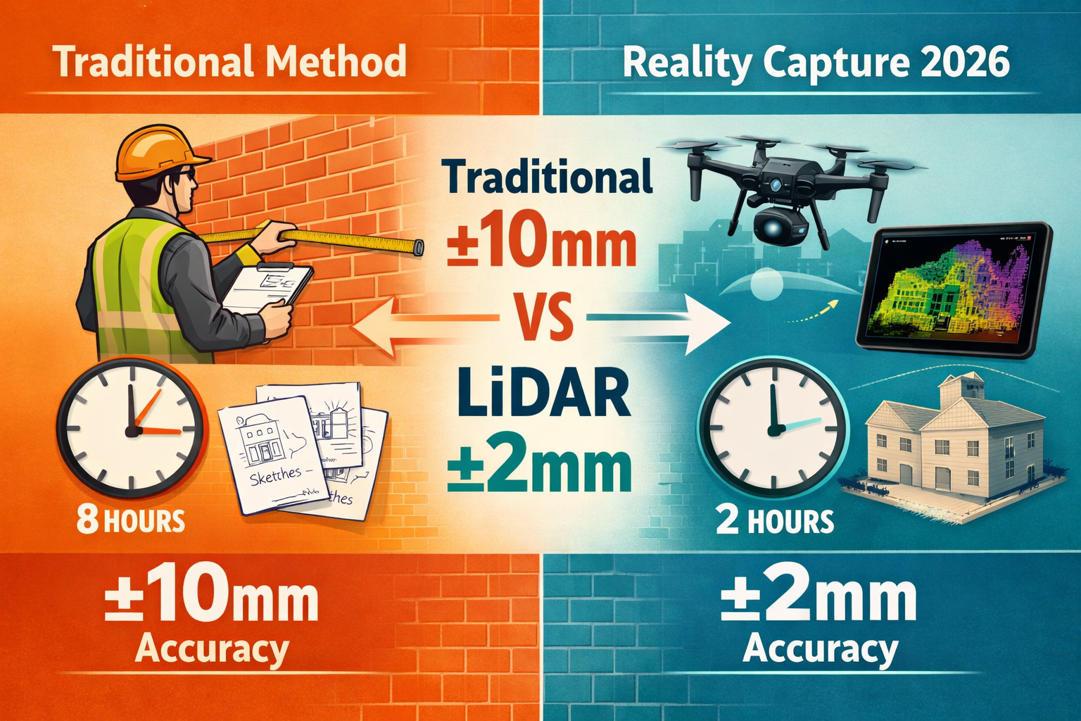
The party wall surveying industry stands at a technological crossroads in 2026. Traditional methods involving tape measures, hand-drawn sketches, and manual documentation are rapidly giving way to reality capture technologies that deliver millimeter-accurate assessments in a fraction of the time. Reality Capture Technologies Revolutionizing Party Wall Surveys: LiDAR and Photogrammetry for 2026 Precision represents more than just an upgrade—it's a fundamental transformation in how surveyors document existing conditions, serve party wall notices, and prepare party wall awards with unprecedented accuracy and speed.
What once took days of on-site measurement and weeks of manual drafting now happens in hours, with laser-precise 3D models replacing subjective observations. This shift has profound implications for property owners, surveyors, and dispute resolution across London and beyond.
Key Takeaways
- LiDAR and photogrammetry have transitioned from novelty to standard practice in party wall surveys by 2026, reducing on-site time by up to 75% while improving accuracy to ±2mm [4]
- Drone-based reality capture enables comprehensive documentation of hard-to-reach areas and complex architectural features that traditional methods cannot safely or accurately assess [3]
- 3D point cloud data provides irrefutable evidence for dispute resolution, accelerating the party wall awards process and reducing conflicts between building owners and adjoining owners
- Cost efficiency has improved dramatically as UAV technology becomes more affordable, making advanced surveying accessible for standard residential party wall matters
- Integration with digital workflows allows surveyors to produce detailed schedules of condition and technical reports faster, benefiting both building owners and adjoining owners
The Shift from Traditional to Reality Capture in Party Wall Assessments
Why Traditional Methods Fall Short in 2026
For decades, party wall surveyors relied on manual measurement techniques—tape measures, spirit levels, and visual inspections—to document existing conditions before construction work commenced. While these methods served their purpose, they introduced several critical limitations:
- Subjective interpretation of structural conditions
- Time-intensive on-site data collection requiring multiple visits
- Limited documentation of complex architectural details
- Measurement errors accumulating across large structures
- Difficulty accessing high walls, roofs, and confined spaces
- Incomplete evidence for potential disputes
These shortcomings became increasingly problematic as construction projects grew more complex and types of party wall works expanded to include sophisticated structural interventions.
The Reality Capture Revolution 📡
3D laser scanning has transitioned from novelty to standard practice in property surveying by 2026, with the technology now being widely adopted for practical implementation across the industry [4]. This transformation reflects both technological advancement and economic accessibility—what once required specialized equipment costing hundreds of thousands of pounds now operates on affordable handheld devices and consumer-grade drones.
Reality capture technologies encompass several complementary approaches:
| Technology | Primary Function | Typical Accuracy | Best Applications |
|---|---|---|---|
| Terrestrial LiDAR | Ground-based laser scanning | ±2-5mm | Interior walls, detailed structural features |
| Drone LiDAR | Aerial laser scanning | ±5-10mm | Roof structures, large building exteriors |
| Photogrammetry | Image-based 3D modeling | ±10-20mm | Visual documentation, texture capture |
| Mobile Scanning | Handheld rapid capture | ±10-15mm | Quick surveys, confined spaces |
LiDAR creates precise 3D point clouds of existing structures, providing essential data for property boundary assessment and detailed structural documentation in party wall surveys [1]. Each point cloud contains millions of individual measurements, creating a comprehensive digital twin of the physical structure.
Real-World Impact: Case Study Evidence
A party wall surveyor in Central London recently documented a basement excavation project beneath a Victorian terrace. Traditional methods would have required:
- 3-4 days of on-site measurement
- Multiple visits to capture all structural details
- 2 weeks of manual drafting and report preparation
- Limited documentation of ceiling heights and structural irregularities
Using drone-based LiDAR and terrestrial scanning, the same project was completed with:
- ⏱️ 4 hours of on-site scanning
- 🎯 Single comprehensive survey capturing all details
- 📊 3 days from scan to final report
- 📐 Complete 3D model with millimeter accuracy
The time savings translated directly to reduced costs for both the building owner and adjoining owner, while the enhanced accuracy eliminated potential measurement disputes before they could arise.
How LiDAR and Photogrammetry Work for Party Wall Precision
Understanding LiDAR Technology in Party Wall Context
Light Detection and Ranging (LiDAR) operates by emitting rapid laser pulses—often hundreds of thousands per second—and measuring the time it takes for each pulse to return after reflecting off surfaces. This time-of-flight measurement, combined with precise positioning data, creates extraordinarily accurate 3D coordinates for every point captured.
For party wall surveys, this means:
- Exact wall positions and deviations from vertical
- Precise measurements of structural elements like beams and columns
- Detailed surface mapping revealing cracks, bulges, and settlement
- Comprehensive documentation of ornamental features and architectural details
GPS surveying establishes precise property boundaries in conjunction with LiDAR, while GIS mapping integrates multiple data sources for comprehensive property analysis [1]. This integration ensures that party wall locations are documented not just accurately, but in proper legal and spatial context.
Photogrammetry: The Visual Complement
While LiDAR excels at geometric precision, photogrammetry provides rich visual context by processing overlapping photographs to create textured 3D models. Modern photogrammetry software can extract accurate measurements from properly calibrated image sets, making it an ideal complement to LiDAR scanning.
Key advantages of photogrammetry for party wall work include:
- 📸 Visual evidence of existing conditions with color and texture
- 💰 Lower equipment costs compared to LiDAR systems
- 🔄 Flexible capture using standard cameras or smartphones
- 📝 Detailed documentation for schedules of condition
The combination of LiDAR's geometric precision and photogrammetry's visual richness creates comprehensive documentation that satisfies both technical requirements and legal evidence standards.
Drone Integration: Accessing the Inaccessible
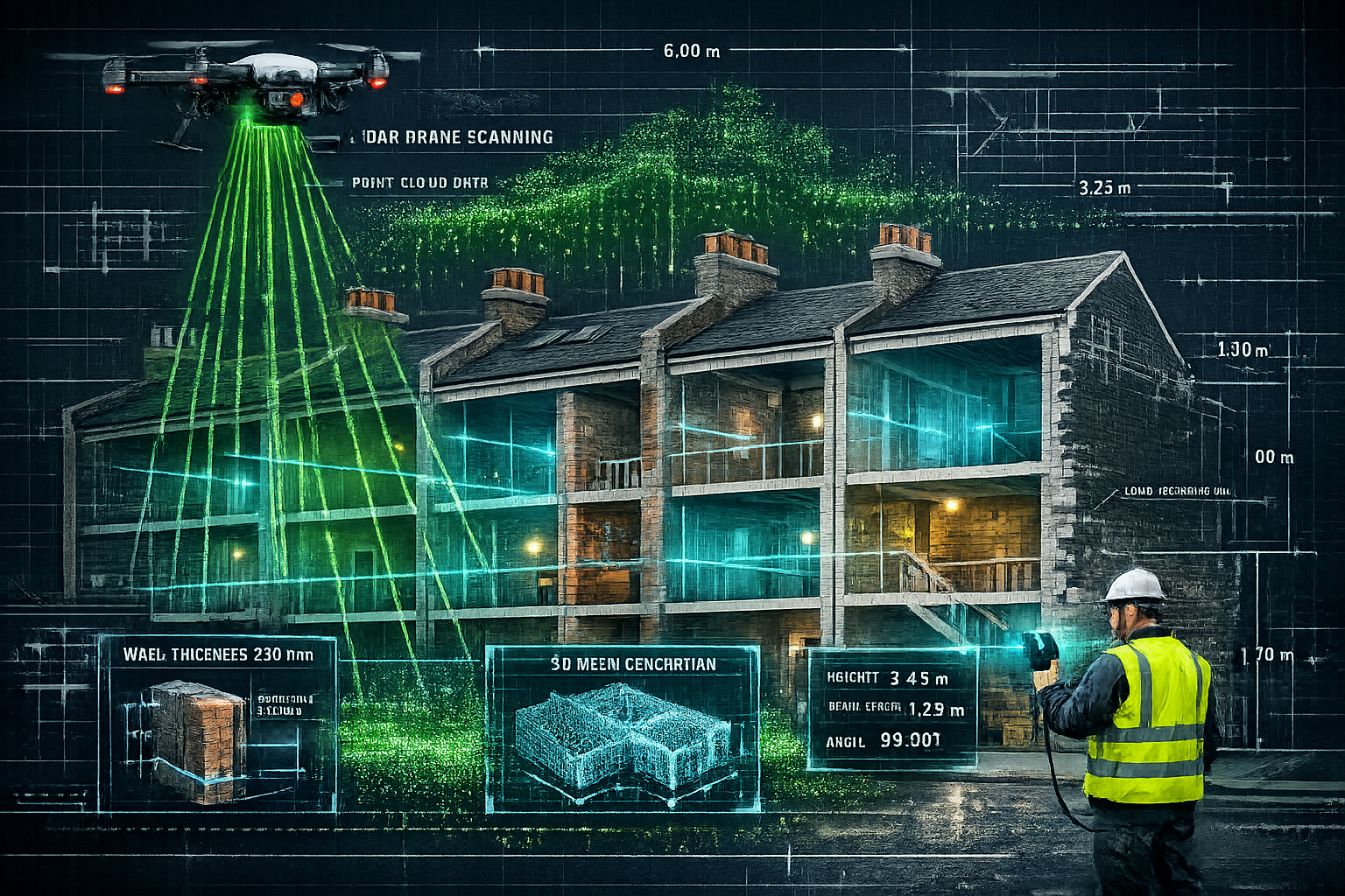
Unmanned aerial vehicles (UAVs) equipped with high-resolution cameras and LiDAR sensors have become more affordable and accessible, enabling surveyors to capture large amounts of accurate topographic data and aerial imagery while covering larger land areas in shorter timeframes [3].
For party wall surveys, this capability proves invaluable when dealing with:
- Tall party walls between multi-story buildings
- Roof structures and chimneys requiring assessment
- Rear elevations with limited ground access
- Complex architectural features at height
Drones can survey difficult terrain and hard-to-reach places that are challenging or impossible to access with traditional surveying methods, making them essential for comprehensive party wall assessments in complex architectural environments [3].
Technical Specifications That Matter
When planning LiDAR missions for party wall surveys, several technical parameters significantly impact data quality and operational efficiency:
LiDAR swath overlap should be set at approximately 20% for area surveys, which differs fundamentally from photogrammetry overlap settings (70-80%), reducing unnecessary flight passes and operational costs [2]. This lower overlap requirement makes LiDAR surveys faster and more economical than photogrammetry for large structures.
Corner radius parameters of 15-20 meters produce smoother turns in LiDAR drone missions, reducing IMU (Inertial Measurement Unit) drift errors caused by sharp directional changes during flight [2]. This technical detail ensures consistent accuracy throughout the entire scan.
Smart AGL (Above Ground Level) altitude mode is recommended for surveys in challenging terrain, as it considers terrain ahead of the drone rather than just below it, preventing dangerous proximity to cliff edges or steep slopes [2]. For urban party wall surveys, this feature helps navigate complex rooflines and varying building heights safely.
Practical Applications: From Notices to Awards with Enhanced Evidence
Accelerating the Party Wall Process 🚀
Reality Capture Technologies Revolutionizing Party Wall Surveys: LiDAR and Photogrammetry for 2026 Precision directly impacts every stage of the party wall process, from initial assessment through final award documentation.
Stage 1: Pre-Notice Assessment
Before serving party wall notices, building owners benefit from rapid reality capture surveys that:
- Identify all affected party structures with precision
- Document existing conditions comprehensively
- Reveal potential structural concerns requiring attention
- Provide accurate data for engineering design
A party wall surveyor in North London reported that preliminary LiDAR scans helped identify a previously unnoticed lean in a party wall, allowing the building owner to address the issue proactively before formal notices were served—avoiding potential disputes and delays.
Stage 2: Schedule of Condition Documentation
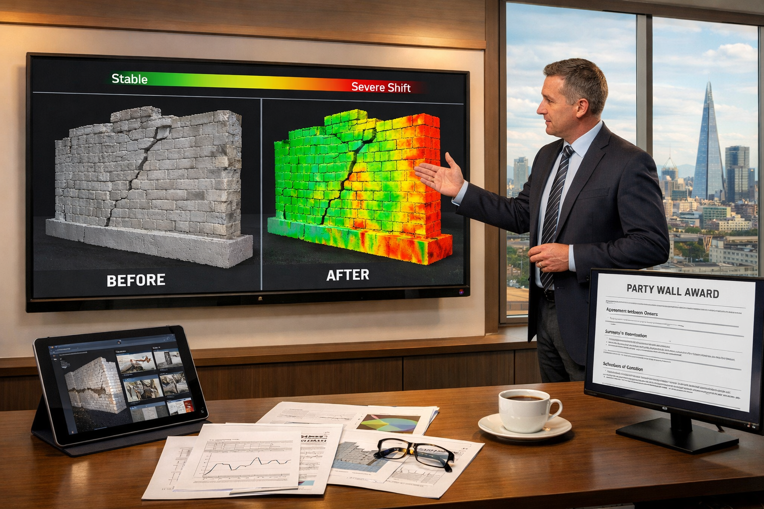
The schedule of condition represents one of the most critical documents in party wall matters, establishing the baseline against which post-construction conditions are compared. Traditional photographic schedules, while useful, lack the precision needed to definitively establish pre-existing conditions.
Reality capture transforms this process by providing:
- ✅ Millimeter-accurate baseline measurements of every surface
- ✅ Complete 3D models showing structural geometry
- ✅ Time-stamped digital evidence with GPS coordinates
- ✅ Objective documentation eliminating subjective interpretation
When disputes arise about whether damage was caused by construction work or existed previously, 3D point cloud data provides irrefutable evidence, often resolving conflicts without expensive litigation.
Stage 3: Monitoring During Construction
UAVs perform multiple surveying functions beyond basic imagery, including photogrammetry, 3D mapping, multispectral mapping, thermal imaging, 2D/3D orthomosaic mapping, and building information modeling (BIM) [3]. These capabilities enable continuous monitoring throughout construction phases.
Progressive scans during construction allow surveyors to:
- Track structural movement with sub-centimeter precision
- Identify emerging issues before they become serious problems
- Document construction progress for all parties
- Provide objective evidence if disputes arise
A recent case involving a party wall surveyor in South London demonstrated this value when weekly drone scans detected a 3mm lateral movement in a party wall during excavation. Early detection allowed immediate corrective measures, preventing what could have become significant structural damage.
Stage 4: Post-Construction Verification
After construction completes, final reality capture surveys provide:
- Comparison analysis between pre- and post-construction conditions
- Deviation mapping showing any structural changes
- Comprehensive documentation for party wall awards
- Evidence base for any necessary remedial work
Dispute Resolution and Legal Evidence
The evidentiary value of reality capture data extends beyond routine surveys into formal dispute resolution. When disagreements arise between building owners and adjoining owners, objective 3D data often resolves conflicts that would otherwise require expensive expert testimony and prolonged legal proceedings.
Courts and arbitrators increasingly recognize the reliability of LiDAR and photogrammetry evidence, particularly when:
- Data collection follows established protocols
- Equipment calibration is documented
- Processing workflows are transparent
- Results are reproducible
This acceptance accelerates party wall awards and reduces the overall costs of the party wall process.
Practical Considerations for Property Owners
For building owners and adjoining owners considering reality capture surveys, several practical factors warrant consideration:
Cost Implications 💷
While reality capture technology requires initial investment, the overall economics favor adoption:
- Reduced survey time = lower professional fees
- Fewer site visits = reduced disruption
- Better documentation = fewer disputes
- Faster project timelines = reduced holding costs
A party wall surveyor in East London reported that reality capture surveys typically add 15-25% to initial survey costs but reduce overall project costs by eliminating disputes and delays.
Access and Permissions 🔑
Reality capture surveys require appropriate access and permissions:
- Drone operations must comply with CAA regulations
- Adjoining property access may be needed for complete coverage
- Privacy concerns require sensitive handling
- Data security protocols protect sensitive information
Data Management and Longevity 💾
Digital survey data offers long-term value:
- Archival records for future reference
- Baseline data for subsequent projects
- Building information for maintenance planning
- Historical documentation preserving structural history
Emerging Trends and Future Developments in 2026
The trajectory of reality capture technology continues upward, with several emerging trends shaping party wall surveying practice in 2026 and beyond:
Artificial Intelligence Integration 🤖
Machine learning algorithms now automatically:
- Detect structural defects from point cloud data
- Classify building elements (walls, floors, openings)
- Generate reports with minimal manual intervention
- Predict maintenance needs based on condition analysis
Real-Time Processing ⚡
Modern mobile devices process reality capture data on-site, enabling:
- Immediate quality verification
- Real-time visualization for clients
- Instant identification of data gaps
- Same-day preliminary reports
Enhanced Sensor Fusion
Combining multiple sensor types produces richer datasets:
- LiDAR + thermal imaging = structural and performance assessment
- Photogrammetry + multispectral = material identification
- GPS + IMU + LiDAR = centimeter-accurate georeferencing
Democratization of Technology
LiDAR surveying offers higher precision and flexibility for surveying both manmade and organic structures, with particular effectiveness in densely vegetated areas where traditional methods cannot provide necessary accuracy [3]. This precision is now available at price points accessible to small surveying practices and even individual property owners.
Smartphone-integrated LiDAR sensors, while less accurate than professional equipment, provide sufficient precision for preliminary assessments and simple party wall matters, further democratizing access to reality capture capabilities.
Regulatory Evolution
Professional bodies and regulatory frameworks are adapting to reality capture technologies:
- RICS guidance increasingly references digital survey methods
- Building control departments accept 3D models as supporting documentation
- Insurance providers recognize enhanced risk management from better documentation
- Legal precedents establish admissibility standards for digital evidence
Implementing Reality Capture: Practical Guidance for Surveyors
For surveyors considering adoption of Reality Capture Technologies Revolutionizing Party Wall Surveys: LiDAR and Photogrammetry for 2026 Precision, a structured implementation approach ensures successful integration:
Equipment Selection Criteria
Entry-level options (£5,000-£15,000):
- Handheld LiDAR scanners (e.g., Leica BLK2GO)
- Consumer drones with photogrammetry capability
- Smartphone-based solutions for simple surveys
Professional systems (£15,000-£50,000):
- Terrestrial laser scanners with survey-grade accuracy
- Drone-mounted LiDAR systems
- Integrated processing software suites
Enterprise solutions (£50,000+):
- Multiple sensor platforms
- Advanced processing workstations
- Comprehensive software ecosystems
Training and Competency Development
Successful implementation requires investment in:
- Technical training on equipment operation
- Software proficiency in processing applications
- Quality assurance protocols and procedures
- Legal understanding of data handling and privacy
Professional development resources include manufacturer training programs, industry conferences, and specialized courses offered by surveying institutions.
Workflow Integration
Reality capture works best when integrated into comprehensive workflows:
- Pre-survey planning → Equipment selection, flight planning, access arrangements
- Data capture → Systematic scanning following established protocols
- Processing → Point cloud cleaning, registration, model generation
- Analysis → Measurement extraction, deviation analysis, defect identification
- Reporting → Automated report generation with 3D visualizations
- Archiving → Secure data storage with version control
Quality Assurance Standards
Maintaining data quality requires:
- Regular equipment calibration following manufacturer specifications
- Redundant measurements for critical features
- Independent verification of key dimensions
- Documentation of survey conditions and limitations
Overcoming Implementation Challenges
While the benefits of reality capture are substantial, surveyors face several implementation challenges:
Technical Complexity
Reality capture systems involve sophisticated technology requiring:
- Understanding of laser scanning principles
- Proficiency with specialized software
- Knowledge of data processing workflows
- Troubleshooting capabilities for technical issues
Solution: Gradual adoption starting with simpler systems, comprehensive training, and vendor support relationships.
Initial Investment Costs
Professional-grade equipment represents significant capital investment, particularly for smaller practices.
Solution: Equipment leasing, project-specific rentals, collaborative equipment sharing among practices, or starting with lower-cost smartphone-based solutions.
Client Education
Property owners may not immediately understand the value proposition of reality capture surveys, particularly if costs exceed traditional methods.
Solution: Clear communication of benefits (time savings, accuracy, dispute prevention), visual demonstrations of 3D models, case study examples showing cost savings from avoided disputes.
Data Management Requirements
Reality capture generates large data files requiring:
- Substantial storage capacity
- Robust backup systems
- Secure data handling protocols
- Long-term archival strategies
Solution: Cloud-based storage solutions, systematic data management protocols, automated backup systems.
Conclusion: Embracing the Future of Party Wall Surveying
Reality Capture Technologies Revolutionizing Party Wall Surveys: LiDAR and Photogrammetry for 2026 Precision represents far more than a technological upgrade—it fundamentally transforms how surveyors document existing conditions, serve notices, prepare awards, and resolve disputes. The shift from subjective manual measurement to objective digital documentation enhances accuracy, reduces timelines, and provides irrefutable evidence that benefits all parties in the party wall process.
The evidence is compelling: reality capture reduces on-site time by 75%, improves accuracy to millimeter precision, and provides comprehensive 3D documentation that traditional methods simply cannot match. As technology becomes more affordable and accessible in 2026, adoption will accelerate from early adopters to industry-wide standard practice.
Actionable Next Steps 📋
For Building Owners:
- Request reality capture surveys when planning types of party wall works
- Understand that higher initial survey costs typically reduce overall project expenses
- Ensure your surveyor provides 3D models and comprehensive digital documentation
For Adjoining Owners:
- Insist on detailed schedules of condition using reality capture technology
- Request access to 3D models showing your property's existing conditions
- Understand your rights regarding survey access and documentation standards
For Surveyors:
- Evaluate reality capture equipment appropriate for your practice scale
- Invest in training and competency development
- Begin with pilot projects to develop workflows and demonstrate value
- Integrate reality capture into standard service offerings
For All Stakeholders:
- Recognize that reality capture is becoming standard practice, not optional technology
- Embrace digital documentation for better outcomes and reduced disputes
- Stay informed about emerging capabilities and evolving best practices
The future of party wall surveying is digital, precise, and efficient. Those who embrace Reality Capture Technologies Revolutionizing Party Wall Surveys: LiDAR and Photogrammetry for 2026 Precision position themselves at the forefront of professional practice, delivering superior outcomes for clients while reducing risks and disputes.
Whether you're a building owner planning construction work, an adjoining owner concerned about protecting your property, or a surveyor seeking to enhance your professional capabilities, reality capture technology offers tangible benefits that justify adoption.
The revolution is here. The question is no longer whether to adopt reality capture technologies, but how quickly you can integrate them into your party wall practice.
References
[1] Party Wall Surveys For Ai Data Centre Developments Rics Protocols Amid 2026 Infrastructure Demand – https://nottinghillsurveyors.com/blog/party-wall-surveys-for-ai-data-centre-developments-rics-protocols-amid-2026-infrastructure-demand
[2] Lidar Mission Planning Ugcs Guide – https://www.sphengineering.com/news/lidar-mission-planning-ugcs-guide
[3] The Future Of Land Surveying Technology And Upcoming Trends In 2026 – https://metricop.com/blogs/land-surveying/the-future-of-land-surveying-technology-and-upcoming-trends-in-2026
[4] 3d Laser Scanning For Property Surveys From Adoption Boom To Practical Implementation – https://nottinghillsurveyors.com/blog/3d-laser-scanning-for-property-surveys-from-adoption-boom-to-practical-implementation