
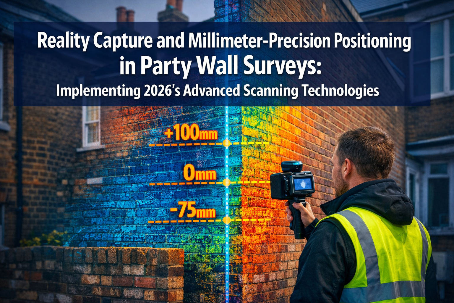
Property boundaries have never been more precise—or more contentious. As London's terraced houses undergo extensive renovations and basement extensions, party wall disputes are rising. The difference between a successful project and a costly legal battle often comes down to millimeters. In 2026, Reality Capture and Millimeter-Precision Positioning in Party Wall Surveys: Implementing 2026's Advanced Scanning Technologies is transforming how surveyors document existing conditions, prevent disputes, and create enforceable awards.
Advanced scanning technologies are no longer reserved for large engineering firms with six-figure budgets. The democratization of reality capture tools means that party wall surveyors across London can now access LiDAR scanners, drone systems, and GNSS-enhanced positioning for under £5,000[5]. This technological shift is revolutionizing how professionals approach schedules of condition, boundary documentation, and dispute resolution under the Party Wall etc. Act 1996.
Key Takeaways
⭐ Reality capture technologies have become affordable and accessible in 2026, with handheld LiDAR systems and smartphone-based tools enabling millimeter-precision documentation for under £5,000.
⭐ Millimeter-level accuracy prevents disputes by providing objective, defensible evidence of existing conditions, boundary positions, and structural movements during party wall works.
⭐ Integration with common data environments (CDEs) allows seamless sharing of point cloud data between surveyors, building owners, and contractors throughout the project lifecycle.
⭐ Multiple capture methods including handheld scanners, drone-mounted systems, and mobile mapping offer flexible solutions for different party wall scenarios and property types.
⭐ AI-enhanced processing enables real-time collaboration and automated deviation analysis, transforming spatial data into actionable insights for party wall awards.
Understanding Reality Capture Technology in Party Wall Context
Reality capture refers to the process of digitally documenting physical spaces using laser scanning, photogrammetry, or other sensing technologies. For party wall surveyors, this means creating highly accurate 3D models of walls, foundations, and adjacent structures before construction begins.
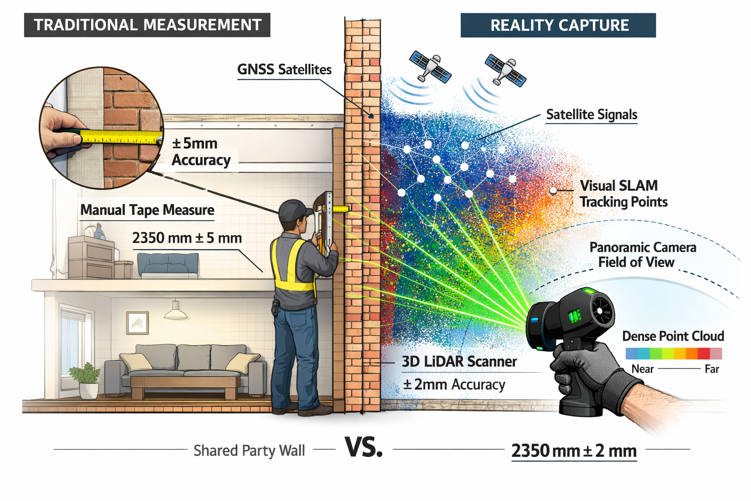
Traditional party wall surveys relied on tape measures, photographs, and hand-drawn sketches. While these methods satisfied legal requirements, they left room for interpretation and dispute. Modern reality capture eliminates ambiguity by creating point cloud datasets—millions of precisely measured points that represent every surface, crack, and feature of a structure.
Why Millimeter Precision Matters
Party wall work often involves excavating within three meters of a neighbor's foundation or cutting into shared structural elements. Even minor settlement or movement can trigger disputes. Millimeter-precision positioning allows surveyors to:
- Document pre-existing cracks and defects with exact dimensions and locations
- Establish baseline measurements that can be compared against post-construction scans
- Identify boundary encroachments that might complicate party wall notices
- Create defensible evidence for potential disputes or insurance claims
According to industry analysis, the democratization of reality capture is accelerating in 2026, with user-friendly tools expanding adoption across surveying firms of all sizes[1]. This shift means that comprehensive data collection is now possible using mobile phones and mobile mapping systems, not just expensive stationary scanners.
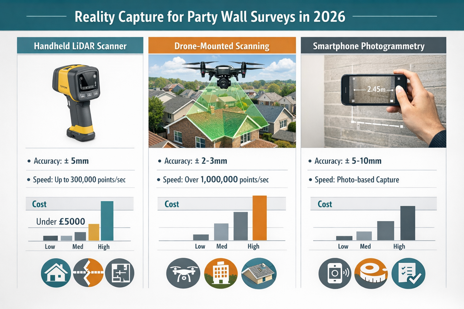
The Technology Stack for 2026
Modern reality capture for party wall surveys combines several technologies:
| Technology | Accuracy | Typical Use Case | Cost Range (2026) |
|---|---|---|---|
| Handheld LiDAR | ±2-5mm | Interior walls, facades, detailed features | £3,000-£15,000 |
| Drone-mounted scanning | ±10-20mm | Rooflines, chimneys, large elevations | £2,000-£8,000 |
| Smartphone photogrammetry | ±10-30mm | Quick documentation, supplementary records | £0-£500 (apps) |
| Terrestrial laser scanning | ±1-3mm | High-precision baseline surveys | £20,000-£80,000 |
| GNSS/GPS positioning | ±5-20mm (RTK) | Boundary verification, georeferencing | £1,500-£10,000 |
Implementing Advanced Scanning Technologies in Party Wall Surveys
The practical implementation of Reality Capture and Millimeter-Precision Positioning in Party Wall Surveys: Implementing 2026's Advanced Scanning Technologies requires understanding both the hardware options and the workflow integration.
Handheld Scanning Systems: The Game-Changer
On February 16, 2026, Topcon introduced the CR-S1 handheld scanning system, combining LiDAR, panoramic cameras, visual SLAM cameras, and GNSS antenna in a single device[4]. This represents a significant advancement over previous models, with increased point-cloud density and extended scanning range.
The CR-S1 supports multiple mounting configurations including:
- Backpack mount for walking through properties and capturing entire floor plans
- Front-pack configuration for detailed wall documentation while maintaining visual contact
- Rover-pole mount for reaching high elevations and rooflines
- Vehicle-mounted options for mobile mapping of entire streets[4]
For party wall surveyors, this versatility means a single device can handle multiple scenarios. A surveyor in East London might use the backpack configuration to scan a terraced house interior, then switch to rover-pole mode to capture the external party wall elevation—all in a single site visit.
Workflow Integration: From Scan to Award
Implementing advanced scanning technologies isn't just about purchasing equipment. It requires rethinking the entire party wall survey workflow:
1. Pre-Work Documentation Phase
- Conduct initial handheld LiDAR scan of all party walls and adjacent structures
- Capture high-resolution panoramic photographs for visual context
- Process point cloud data to create baseline 3D model
- Extract precise measurements of existing cracks, defects, and features
- Generate detailed schedule of condition with embedded 3D data
2. Data Management and Sharing
Common data environments (CDEs) are becoming standard in construction, with improved interoperability between software platforms[1]. For party wall work, this means:
- Uploading point cloud data to cloud-based platforms accessible by all parties
- Sharing interactive 3D models with building owners and adjoining owners
- Enabling remote review and annotation without site visits
- Maintaining version control as projects progress
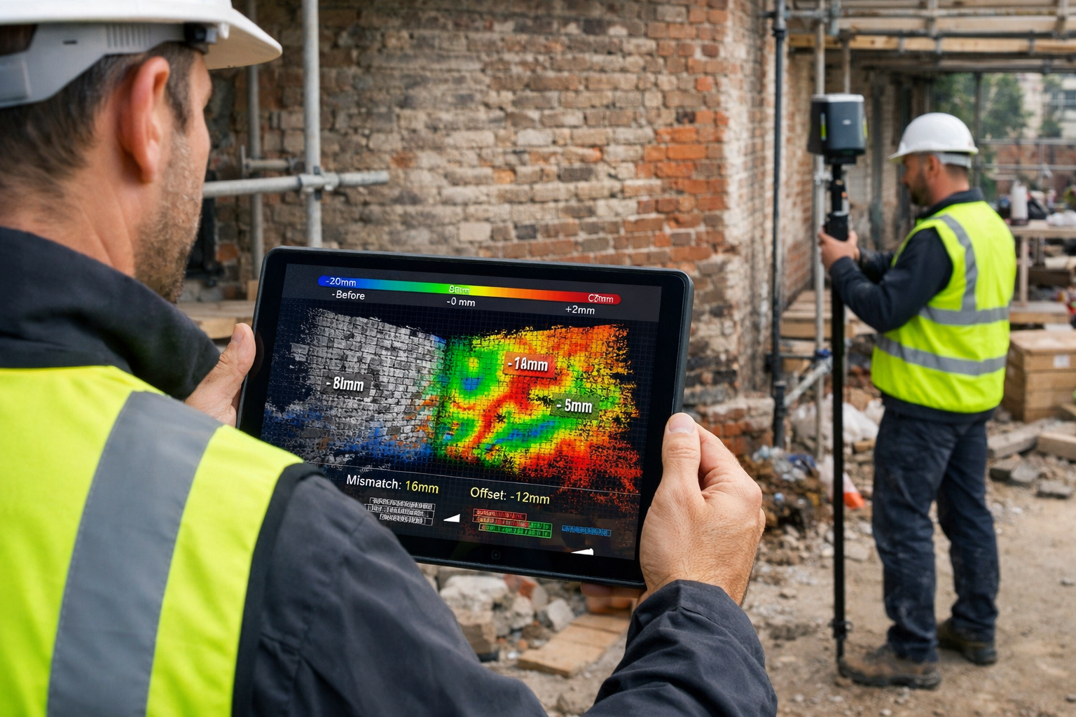
3. Monitoring and Comparison
During construction, periodic rescanning allows surveyors to:
- Detect structural movement or settlement with millimeter precision
- Compare current conditions against baseline scans
- Generate automated deviation reports highlighting changes
- Identify potential issues before they become disputes
4. Post-Work Verification
Final scanning provides objective evidence that:
- Works were completed as specified in the party wall award
- No unintended damage occurred to adjoining properties
- Any agreed remedial work was properly executed
- Final conditions meet regulatory and contractual requirements
Cost-Benefit Analysis for Small Firms
One of the most significant developments in 2026 is the accessibility of reality capture tools for small surveying practices. Sources reference affordable options under £5,000 enabling small surveying firms to adopt advanced technologies[5].
Investment Breakdown for a Small Practice:
- Entry-level handheld LiDAR scanner: £3,500-£4,500
- Processing software subscription: £50-£150/month
- Cloud storage and CDE access: £30-£100/month
- Training and certification: £500-£1,500 (one-time)
- Total first-year investment: £5,500-£8,000
Return on Investment:
- Reduced site visit time: 40-60% faster data collection compared to traditional methods
- Fewer disputes: Objective documentation reduces disagreement and litigation costs
- Premium service offering: Ability to charge 15-25% more for technology-enhanced surveys
- Competitive advantage: Differentiation in crowded market
- Risk mitigation: Reduced professional indemnity claims due to better documentation
For a practice handling 50 party wall surveys annually, the technology investment typically pays for itself within 12-18 months through efficiency gains and reduced dispute resolution costs.
Advanced Applications of Reality Capture and Millimeter-Precision Positioning in Party Wall Surveys
Beyond basic documentation, Reality Capture and Millimeter-Precision Positioning in Party Wall Surveys: Implementing 2026's Advanced Scanning Technologies enables sophisticated applications that were impractical just a few years ago.
AI-Enhanced Analysis and Automated Reporting
AI and machine learning integration with reality capture enables real-time collaboration and decision-making, positioning spatial data as a common visual language for project stakeholders[1]. For party wall surveyors, this translates to:
Automated Crack Detection and Classification:
- Machine learning algorithms identify and measure cracks in point cloud data
- Automatic classification by severity (hairline, minor, moderate, severe)
- Tracking of crack progression over time with millimeter precision
- Predictive analysis of potential failure points
Deviation Analysis:
- Automated comparison between baseline and current scans
- Heat map visualization showing areas of movement or settlement
- Threshold alerts when changes exceed specified tolerances
- Integration with party wall awards to verify compliance
Intelligent Report Generation:
- Automatic extraction of measurements and annotations from point cloud data
- Template-based report creation with embedded 3D visualizations
- Cross-referencing with Party Wall Act requirements
- Standardized formatting for legal and regulatory submissions
Boundary Dispute Resolution
Precise positioning technology is particularly valuable for resolving boundary disputes that complicate party wall matters. When combined with GNSS/RTK positioning, reality capture can:
- Verify property boundaries against Land Registry plans with centimeter accuracy
- Identify encroachments where structures extend beyond legal boundaries
- Document party fence walls and their precise location relative to boundaries
- Provide expert evidence in boundary disputes that affect party wall work
This capability is especially relevant for surveyors in Central London, where properties are tightly packed and boundary precision is critical.
Integration with Building Information Modeling (BIM)
Geo Week 2026 featured sessions from the Reality Capture Network emphasizing integration across project phases, disciplines, and long-term asset management[2]. For party wall work, BIM integration offers:
Design Coordination:
- Import point cloud data of existing structures into BIM models
- Clash detection between proposed works and existing party walls
- Accurate modeling of types of party wall works
- Coordination between architects, structural engineers, and surveyors
Lifecycle Documentation:
- Creating permanent digital twins of party wall structures
- Maintaining historical records of all modifications and repairs
- Supporting future renovation planning with accurate as-built data
- Reducing costs of party wall processes through better information management
Drone-Based Scanning for Complex Properties
For properties with difficult-to-access features, drone-mounted scanning systems provide unique advantages:
- Roofline and chimney documentation without scaffolding or access equipment
- Large elevation capture of entire terraces or apartment blocks
- Aerial perspective for understanding spatial relationships between properties
- Thermal imaging integration to identify structural issues not visible to the naked eye
When serving party structure notices for roof or chimney work, drone-captured data provides comprehensive baseline documentation that protects all parties.
Best Practices for Implementing 2026's Scanning Technologies
Successfully implementing Reality Capture and Millimeter-Precision Positioning in Party Wall Surveys: Implementing 2026's Advanced Scanning Technologies requires more than just purchasing equipment. Consider these best practices:
🎯 Training and Competency Development
Technical Skills:
- Proper scanner operation and calibration procedures
- Understanding point cloud data quality and density requirements
- Software proficiency for processing and analysis
- Troubleshooting common scanning challenges
Professional Application:
- Knowing when reality capture adds value versus traditional methods
- Understanding legal admissibility of digital evidence
- Communicating technical findings to non-technical clients
- Integrating scan data with party wall notices and awards
📋 Standardized Protocols and Procedures
Develop consistent workflows that ensure:
- Scan density and resolution appropriate for party wall documentation
- Registration accuracy when combining multiple scan positions
- Quality control checks before leaving site
- Data backup and archival procedures for long-term storage
- Naming conventions that integrate with existing file management systems
🤝 Client Communication and Education
Many property owners and building owners are unfamiliar with reality capture technology. Effective communication includes:
- Explaining the benefits in terms of dispute prevention and cost savings
- Demonstrating the technology through sample visualizations
- Setting realistic expectations about what the technology can and cannot do
- Providing accessible outputs such as 3D PDFs or web-based viewers
- Transparent pricing that justifies the technology premium
🔒 Data Security and Privacy
Point cloud data contains detailed information about properties and may reveal security-sensitive features. Best practices include:
- Secure storage with encryption and access controls
- GDPR compliance when capturing data about occupied properties
- Client consent for data sharing and retention
- Anonymization when using data for training or marketing purposes
- Retention policies aligned with professional indemnity requirements
⚖️ Legal and Regulatory Considerations
While reality capture provides superior documentation, ensure:
- Compliance with Party Wall Act requirements for schedules of condition
- Admissibility of digital evidence in potential disputes
- Professional standards alignment with RICS guidance
- Insurance coverage that includes technology-enhanced services
- Clear contractual terms regarding data ownership and usage rights
Overcoming Implementation Challenges
Despite the benefits, surveying practices may encounter challenges when adopting advanced scanning technologies:
Challenge 1: Initial Cost Barrier
Solution: Consider equipment leasing, shared ownership with partner firms, or starting with smartphone-based photogrammetry before investing in dedicated hardware. Many suppliers offer trial periods or demonstration programs.
Challenge 2: Learning Curve
Solution: Invest in structured training programs and start with simpler projects to build competency. Partner with experienced practitioners for initial implementations. Many software vendors offer free training resources and certification programs.
Challenge 3: Client Resistance
Solution: Offer hybrid approaches that combine traditional and advanced methods. Provide case studies demonstrating dispute prevention and cost savings. Consider absorbing technology costs initially to build portfolio of successful implementations.
Challenge 4: Data Management Complexity
Solution: Implement cloud-based CDEs from the outset rather than trying to manage files locally. Establish clear protocols before accumulating large datasets. Consider outsourcing processing to specialized service providers during transition period.
Challenge 5: Technology Evolution
Solution: Focus on platforms with strong vendor support and active user communities. Choose systems with open data formats rather than proprietary lock-in. Budget for ongoing upgrades and training as technology evolves.
Future Trends: What's Next for Reality Capture in Party Wall Surveys
Looking beyond 2026, several emerging trends will further transform party wall surveying:
🚀 Augmented Reality (AR) Integration
Surveyors will use AR headsets to overlay point cloud data onto physical structures in real-time, enabling:
- Instant comparison between baseline and current conditions
- On-site visualization of proposed works relative to existing structures
- Remote expert guidance during complex surveys
- Interactive client presentations during site visits
🤖 Fully Automated Monitoring
Permanent sensors and periodic automated scanning will enable:
- Continuous monitoring of party walls during construction
- Instant alerts when movement exceeds thresholds
- Reduced need for manual inspection visits
- Comprehensive historical records for insurance and legal purposes
🌐 Blockchain-Based Data Authentication
Immutable records of scan data will provide:
- Tamper-proof evidence of existing conditions
- Timestamped verification of when scans were captured
- Enhanced legal admissibility in dispute resolution
- Transparent audit trails for regulatory compliance
📱 Consumer-Grade Reality Capture
As smartphone sensors improve, property owners themselves may capture preliminary data:
- Reducing surveyor site visit requirements
- Enabling remote preliminary assessments
- Lowering costs for straightforward projects
- Democratizing access to basic documentation
Conclusion
Reality Capture and Millimeter-Precision Positioning in Party Wall Surveys: Implementing 2026's Advanced Scanning Technologies represents a fundamental shift in how professionals document, monitor, and manage party wall matters. The democratization of these tools means that practices of all sizes can now access millimeter-precision documentation that was previously available only to large engineering firms.
The benefits extend far beyond technological sophistication. Objective, defensible evidence prevents disputes before they escalate. Comprehensive baseline documentation protects all parties involved in construction projects. Efficient data collection reduces costs and project timelines. Integration with modern digital workflows positions surveyors as strategic partners rather than regulatory gatekeepers.
For party wall surveyors looking to remain competitive in 2026 and beyond, the question is no longer whether to adopt reality capture technologies, but how quickly to implement them effectively. The practices that embrace these tools today will set the standard for professional excellence tomorrow.
🎯 Actionable Next Steps
- Assess your current practice: Identify which party wall projects would benefit most from reality capture technology
- Research equipment options: Evaluate handheld scanners, drone systems, and software platforms within your budget
- Invest in training: Develop technical competencies before purchasing expensive equipment
- Start small: Pilot reality capture on a few projects to build experience and demonstrate value
- Develop standardized workflows: Create protocols that integrate scanning into your existing processes
- Educate your clients: Communicate the benefits of technology-enhanced surveys to build demand
- Connect with peers: Join professional networks and attend events like Geo Week to stay current with evolving best practices
The future of party wall surveying is digital, precise, and accessible. By implementing 2026's advanced scanning technologies today, surveyors can deliver superior service, prevent costly disputes, and build practices positioned for long-term success in an increasingly competitive market.
For more information about party wall procedures and professional surveying services, explore our comprehensive guides on party wall awards, schedules of condition, and types of party wall works.
References
[1] Doubling Down On Digital – https://amerisurv.com/2026/02/01/doubling-down-on-digital/
[2] Geo Week 2026 Highlights Reality Capture S Strategic Role – https://www.gim-international.com/content/news/geo-week-2026-highlights-reality-capture-s-strategic-role
[4] Topcon Expands Capture Reality Portfolio With Introduction Of New Handheld Scanning System – https://www.topconpositioning.com/us/en/articles/topcon-expands-capture-reality-portfolio-with-introduction-of-new-handheld-scanning-system
[5] Democratizing Reality Capture Affordable Tools Empowering Small Surveying Firms In 2026 – https://nottinghillsurveyors.com/blog/democratizing-reality-capture-affordable-tools-empowering-small-surveying-firms-in-2026