

Modern construction projects in 2026 face unprecedented complexity when managing shared property boundaries. GIS Integration for Party Wall Agreements: Mapping Shared Boundaries and Risks in 2026 Developments represents a transformative approach that combines geographic information systems with traditional surveying practices. This technology-driven methodology enables surveyors, developers, and property owners to visualize, analyze, and document shared boundaries with precision that was impossible just a few years ago.
The integration of spatial data, utility mapping, and zoning information into party wall agreement processes creates a comprehensive framework for preventing disputes before they arise. As development density increases across urban areas, the need for accurate boundary documentation becomes critical to compliance with the Party Wall etc. Act 1996.

Key Takeaways
✅ GIS technology overlays multiple data layers (boundaries, utilities, zoning) to provide comprehensive spatial analysis for party wall agreements
✅ Early integration of GIS mapping in project planning reduces disputes by identifying boundary conflicts and risks before construction begins
✅ Digital documentation created through GIS systems ensures Act-compliant records that are accessible, shareable, and legally defensible
✅ Risk visualization through heat maps and spatial analysis helps surveyors prioritize high-risk boundaries requiring additional attention
✅ Cost savings result from reduced surveying time, fewer disputes, and streamlined communication between all parties involved
Understanding GIS Technology in Modern Party Wall Surveying
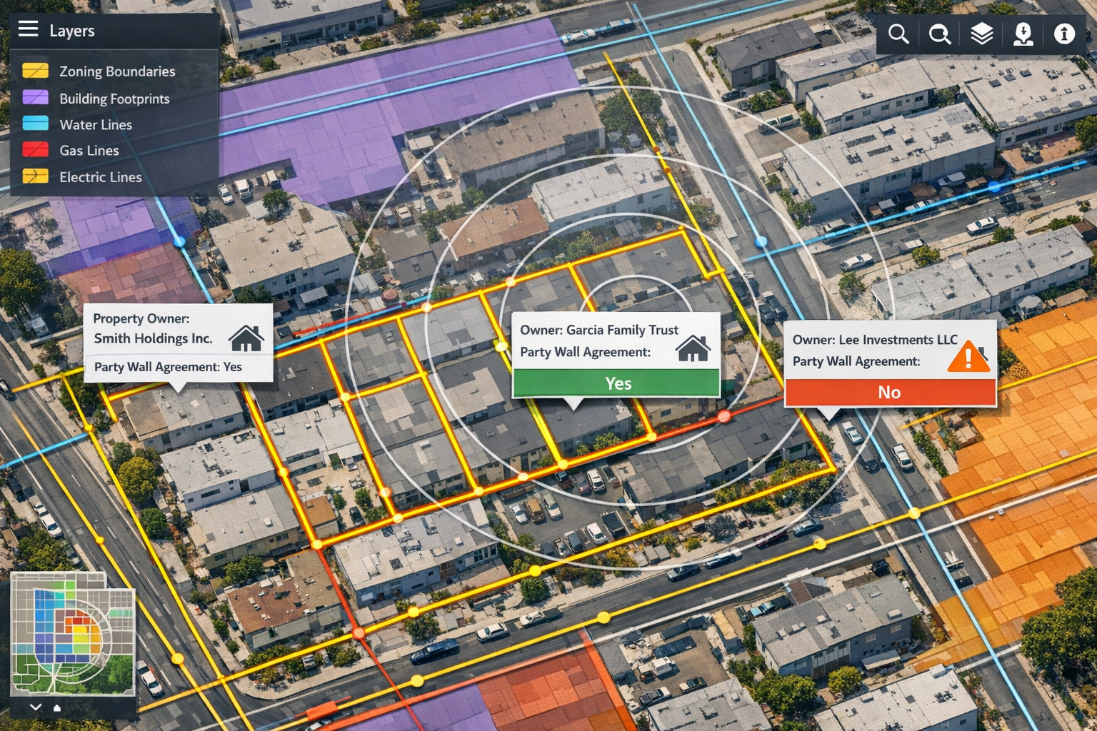
Geographic Information Systems (GIS) function as powerful data integration frameworks that enable governments, companies, and communities to act with greater intelligence.[1] In the context of party wall agreements, GIS transforms how surveyors collect, analyze, and present boundary information.
What Makes GIS Different from Traditional Surveying Methods
Traditional party wall surveying relies heavily on physical site visits, manual measurements, and paper-based documentation. While these methods remain essential, they lack the comprehensive spatial context that GIS provides. GIS integration brings together:
- 📍 Cadastral boundary data from land registry systems
- 🔧 Utility infrastructure mapping showing underground and overhead services
- 🏗️ Zoning and planning constraints affecting development rights
- 📐 Topographic information revealing elevation changes and drainage patterns
- 🏘️ Building footprint data showing existing structures and extensions
This multi-layered approach allows surveyors to identify potential conflicts that wouldn't be apparent from ground-level inspection alone. For instance, a proposed basement excavation might appear straightforward until GIS mapping reveals a major sewer line running directly beneath the shared boundary.
Core GIS Components for Party Wall Applications
Modern GIS platforms designed for property and construction applications include several key components:
| Component | Function | Party Wall Application |
|---|---|---|
| Spatial Database | Stores geographic coordinates and attributes | Property boundaries, ownership records, historical agreements |
| Mapping Interface | Visualizes data layers | Interactive boundary maps, risk zones, notification areas |
| Analysis Tools | Performs spatial calculations | Distance measurements, buffer zones, overlap detection |
| Data Integration | Connects external sources | Land registry, utility companies, planning authorities |
| Reporting Module | Generates documentation | Party wall awards, schedules of condition, notification records |
The ability to integrate data from multiple authoritative sources creates a single source of truth for all parties involved in the agreement process. This reduces ambiguity and provides clear visual evidence when serving party wall notices.
GIS Integration for Party Wall Agreements: Benefits for 2026 Development Projects

The construction landscape in 2026 demands more sophisticated approaches to managing shared boundaries. GIS Integration for Party Wall Agreements: Mapping Shared Boundaries and Risks in 2026 Developments offers tangible benefits that address the challenges of modern high-density construction.
Enhanced Boundary Accuracy and Dispute Prevention
Boundary disputes represent one of the most common sources of conflict in party wall matters. GIS technology dramatically improves accuracy by:
- Overlaying multiple data sources to verify boundary locations
- Identifying discrepancies between registered boundaries and physical features
- Documenting historical boundary movements through temporal data analysis
- Providing coordinate-based measurements that eliminate ambiguity
When surveyors can present clear visual evidence of boundary locations using authoritative data sources, adjoining owners are more likely to accept the findings. This reduces the likelihood of disputes that can delay projects and increase costs.
"Early integration of party wall considerations into site selection and project planning, with adequate budgeting for professional surveyor fees, is essential for modern developments."[2]
Comprehensive Risk Assessment Through Spatial Analysis
GIS mapping enables surveyors to conduct sophisticated risk assessments that go beyond traditional visual inspections. Spatial analysis tools can identify:
🔴 High-risk boundaries where structural work may affect multiple adjoining properties
🟡 Medium-risk areas with utility conflicts or complex ownership arrangements
🟢 Low-risk sections where standard procedures will suffice
This risk-based approach allows surveyors to allocate resources efficiently, focusing detailed investigation on areas where problems are most likely to occur. For guidance on boundary wall rules and party fence walls, GIS provides the spatial context needed to distinguish between different boundary types.
Streamlined Communication and Documentation
One of the most practical benefits of GIS integration is improved communication among stakeholders. Interactive maps can be shared digitally with:
- Building owners who need to understand the scope of proposed works
- Adjoining owners who want to see exactly how work will affect their property
- Surveyors coordinating between multiple parties
- Contractors who need precise location information for safe execution
Digital documentation created through GIS systems is easily updated, version-controlled, and accessible from any location. This is particularly valuable when working with party wall surveyors across different London areas, as all parties can access the same current information.
Implementing GIS Integration for Party Wall Agreements: Practical Applications

Understanding the benefits of GIS Integration for Party Wall Agreements: Mapping Shared Boundaries and Risks in 2026 Developments is one thing; implementing it effectively requires practical knowledge of workflows and best practices.
Step-by-Step GIS Integration Workflow
Phase 1: Data Collection and Preparation
The foundation of any GIS-based party wall assessment begins with gathering relevant spatial data:
- Obtain cadastral data from the Land Registry showing registered boundaries
- Request utility records from service providers (water, gas, electric, telecoms)
- Access planning data from local authorities including zoning and constraints
- Collect topographic surveys showing ground levels and existing structures
- Gather historical records of previous party wall agreements in the area
This data must be processed to ensure compatibility with the GIS platform being used. Coordinate systems should be standardized, and data quality checked for accuracy.
Phase 2: Spatial Analysis and Risk Mapping
Once data is loaded into the GIS system, surveyors can perform various analyses:
- Buffer analysis to determine which properties fall within notification distances
- Overlay analysis to identify conflicts between proposed works and existing features
- Proximity analysis to assess how close excavations will come to neighboring foundations
- Viewshed analysis to understand sight lines and potential privacy impacts
The results of these analyses inform the party wall agreement documentation and help surveyors anticipate questions from adjoining owners.
Phase 3: Documentation and Reporting
GIS systems excel at generating professional documentation that meets legal requirements:
- Annotated maps showing exact boundary locations and proposed work areas
- Schedule of condition reports with georeferenced photographs
- Notification area maps identifying all properties requiring formal notice
- Risk assessment reports highlighting areas requiring special attention
These documents can be exported in various formats suitable for different purposes, from detailed technical drawings to simplified overview maps for property owners unfamiliar with construction terminology.
Integration with Traditional Party Wall Procedures
GIS integration enhances rather than replaces traditional party wall procedures. The technology works best when combined with:
- Physical site inspections to verify GIS data against real-world conditions
- Professional surveyor expertise in interpreting spatial data within legal frameworks
- Face-to-face consultations with building and adjoining owners
- Detailed condition surveys documenting existing structures before work begins
For those wondering about having a party wall agreement without a surveyor, GIS data can help property owners understand the complexity of their situation, but professional interpretation remains essential for compliance with the Act.
Case Study Applications in 2026 Developments
Modern development projects demonstrate the practical value of GIS integration:
Dense Urban Infill Projects: In areas with multiple adjoining properties, GIS mapping identifies all parties requiring notification and visualizes the cumulative impact of works on surrounding buildings.
Basement Excavations: Three-dimensional GIS analysis reveals underground utility conflicts and foundation depths of neighboring properties, critical information for safe excavation planning.
Data Centre Developments: As noted in 2026 compliance guidance for AI-driven UK demand, party wall planning should include early integration of considerations into site selection and project planning.[2] GIS enables developers to assess boundary constraints before committing to a site.
Terraced Housing Extensions: GIS overlays help surveyors understand complex ownership patterns in terraced rows and identify which properties share which walls, essential for proper party structure notice procedures.
Overcoming Challenges in GIS Implementation for Party Wall Work
While the benefits of GIS Integration for Party Wall Agreements: Mapping Shared Boundaries and Risks in 2026 Developments are substantial, implementation comes with challenges that surveyors must address.
Data Quality and Availability Issues
Challenge: Not all areas have comprehensive, up-to-date spatial data available. Older properties may have poorly documented boundaries, and utility records may be incomplete.
Solution: Surveyors should:
- Validate GIS data through physical surveys and measurements
- Document data quality limitations in reports
- Use multiple data sources to cross-verify information
- Update GIS databases with field-collected data to improve future accuracy
The costs of party wall processes may increase slightly with GIS integration initially, but long-term savings from dispute prevention typically outweigh these costs.
Technical Skill Requirements
Challenge: Traditional surveyors may lack GIS expertise, while GIS specialists may not understand party wall legislation.
Solution: Professional development should focus on:
- Training programs combining surveying skills with GIS technology
- Collaboration between GIS specialists and experienced party wall surveyors
- User-friendly GIS platforms designed specifically for property professionals
- Standardized workflows that simplify complex GIS operations
Legal Recognition and Acceptance
Challenge: Courts and dispute resolution processes may be unfamiliar with GIS-generated evidence.
Solution: Surveyors should:
- Present GIS outputs alongside traditional documentation
- Clearly explain data sources and methodology in reports
- Ensure all GIS-generated maps include proper scale bars, legends, and metadata
- Maintain detailed records of how spatial analyses were performed
When properly documented, GIS evidence can actually strengthen legal positions by providing objective, verifiable data about boundary locations and potential impacts.
Cost-Benefit Considerations for Different Project Scales
Challenge: GIS integration may seem cost-prohibitive for smaller projects.
Solution: Consider scalable approaches:
| Project Scale | GIS Integration Level | Cost-Effectiveness |
|---|---|---|
| Single residential extension | Basic boundary mapping with free/low-cost tools | Moderate – may not justify full GIS platform |
| Multi-unit development | Comprehensive GIS analysis with commercial software | High – prevents multiple disputes |
| Large commercial project | Full GIS integration with custom analysis | Very high – essential for complex coordination |
| Infrastructure development | Enterprise GIS with real-time collaboration | Critical – mandatory for risk management |
Even small projects benefit from viewing freely available spatial data through online mapping platforms before commencing types of party wall works.
Future Trends: GIS and Party Wall Agreements Beyond 2026
The trajectory of GIS technology suggests several developments that will further transform party wall practice in coming years:
Artificial Intelligence and Automated Risk Assessment
Machine learning algorithms will analyze historical party wall disputes to identify patterns and predict risk factors automatically. AI-powered systems could flag potential issues based on:
- Property age and construction type combinations
- Soil conditions and foundation types
- Historical settlement patterns in the area
- Proximity to underground infrastructure
These predictive capabilities will enable even more proactive dispute prevention.
Real-Time Monitoring and IoT Integration
Internet of Things (IoT) sensors installed during construction can feed real-time data into GIS systems, monitoring:
- Vibration levels affecting adjoining properties
- Ground movement during excavation
- Structural stress on shared walls
- Environmental conditions like noise and dust
This data creates a continuous record demonstrating compliance with agreed-upon working methods and provides early warning of potential damage.
Blockchain for Immutable Boundary Records
Distributed ledger technology may eventually provide tamper-proof records of party wall agreements and boundary determinations, with spatial data stored on blockchain platforms ensuring permanent, verifiable documentation.
Virtual and Augmented Reality Visualization
VR and AR technologies will allow building and adjoining owners to "walk through" proposed works virtually, understanding spatial relationships and potential impacts more intuitively than traditional plans allow. This could significantly improve consent rates and reduce misunderstandings.
Best Practices for Surveyors Adopting GIS Integration
For party wall surveyors looking to implement GIS Integration for Party Wall Agreements: Mapping Shared Boundaries and Risks in 2026 Developments, these best practices ensure successful adoption:
1. Start with Clear Objectives
Define what you want to achieve with GIS integration:
- Faster boundary verification?
- Better risk assessment?
- Improved client communication?
- Enhanced documentation quality?
Clear goals guide technology selection and implementation priorities.
2. Choose Appropriate Technology
Not all GIS platforms are created equal. Consider:
- Desktop GIS software (QGIS, ArcGIS) for detailed analysis
- Cloud-based platforms for collaboration and accessibility
- Mobile GIS apps for field data collection
- Specialized property platforms with built-in party wall workflows
The right choice depends on your practice size, project types, and budget.
3. Establish Data Management Protocols
Implement systematic approaches to:
- Data acquisition and licensing
- Quality control and validation
- Version control and updates
- Backup and security
- Client data privacy compliance
Poor data management undermines the benefits of even the most sophisticated GIS technology.
4. Maintain Professional Standards
GIS integration should enhance, not replace, professional judgment. Always:
- Verify digital data through physical inspection
- Clearly communicate limitations and uncertainties
- Maintain detailed methodology documentation
- Follow established party wall contract template guidelines
- Keep current with both GIS technology and party wall legislation
5. Invest in Continuous Learning
Technology evolves rapidly. Commit to:
- Regular training on new GIS capabilities
- Participation in professional forums discussing spatial technology
- Experimentation with emerging tools and techniques
- Knowledge sharing within the surveying community
Conclusion: Embracing Spatial Intelligence for Better Party Wall Outcomes
GIS Integration for Party Wall Agreements: Mapping Shared Boundaries and Risks in 2026 Developments represents more than just technological advancement—it embodies a fundamental shift toward data-driven, proactive property boundary management. By overlaying zoning information, utility infrastructure, and cadastral boundaries into comprehensive spatial frameworks, surveyors can identify potential conflicts before they escalate into costly disputes.
The benefits are clear: enhanced accuracy, comprehensive risk assessment, streamlined communication, and legally defensible documentation. As development density increases and construction projects grow more complex, the ability to visualize and analyze spatial relationships becomes not just advantageous but essential for compliance with the Party Wall etc. Act 1996.
Actionable Next Steps
For building owners planning construction projects:
- Request that your surveyor incorporate GIS analysis into boundary assessments
- Ask to see spatial data visualizations showing your project's relationship to adjoining properties
- Budget for professional surveyor fees that include comprehensive spatial analysis[2]
For adjoining owners receiving party wall notices:
- Request GIS-based documentation showing exactly how proposed works will affect your property
- Use spatial data to ask informed questions about potential impacts
- Consider whether independent GIS analysis might be valuable for complex projects
For party wall surveyors:
- Begin exploring GIS platforms suitable for property work
- Invest in training that combines spatial technology with party wall expertise
- Start with pilot projects to develop workflows before full-scale implementation
- Join professional networks discussing GIS applications in surveying practice
For developers and contractors:
- Integrate party wall considerations into early project planning using GIS site analysis
- Work with surveyors who can provide comprehensive spatial risk assessments
- Use GIS-generated documentation to improve communication with all stakeholders
The integration of geographic information systems into party wall practice is not a distant future possibility—it's happening now in 2026. Those who embrace this technology position themselves to deliver superior outcomes: fewer disputes, faster resolutions, better-informed decisions, and ultimately, more successful development projects that respect the rights and interests of all property owners involved.
Whether you're working in North London, South London, East London, or West London, the principles of GIS integration apply universally. The technology adapts to local conditions while providing consistent, high-quality spatial analysis that elevates party wall practice to meet the demands of modern construction.
By mapping shared boundaries and risks with unprecedented precision, GIS integration ensures that party wall agreements fulfill their fundamental purpose: protecting the rights of all parties while enabling responsible development to proceed efficiently and harmoniously.
References
[1] An 2026 48 1 Winter – https://www.esri.com/content/dam/esrisites/en-us/newsroom/arcnews/an-2026-48-1-winter.pdf
[2] Party Wall Agreements In Data Centre Developments 2026 Compliance Amid Ai Driven Uk Demand – https://nottinghillsurveyors.com/blog/party-wall-agreements-in-data-centre-developments-2026-compliance-amid-ai-driven-uk-demand